You are here: Home > Network List > CI - Caltech Regional Seismic Network Stations List
> Station LRL Laurel Mtn Radio Fac, Ridgecrest, CA, USA > Earthquake Result Viewer
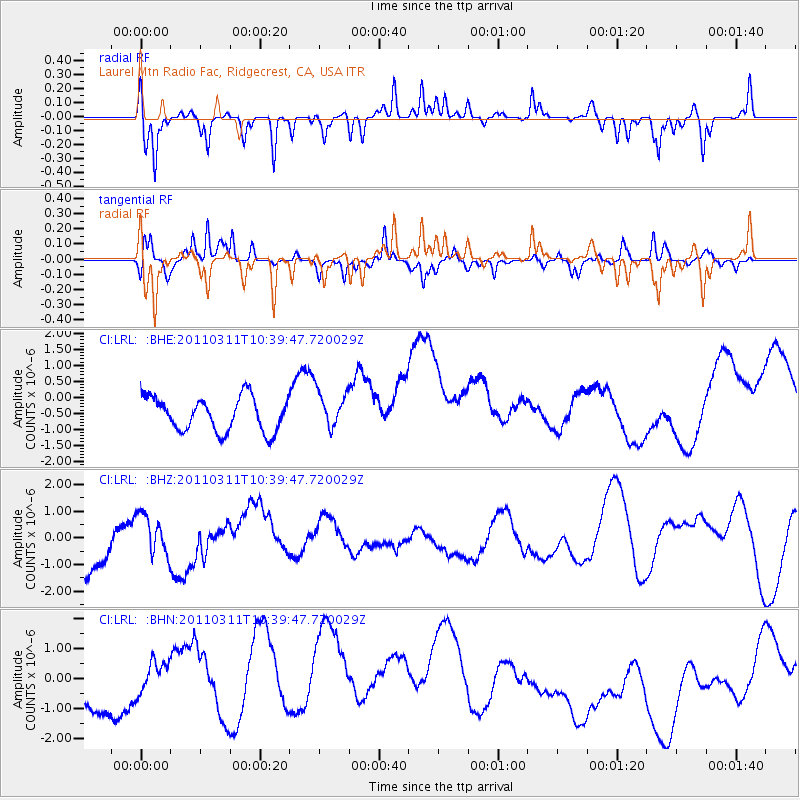
LRL Laurel Mtn Radio Fac, Ridgecrest, CA, USA - Earthquake Result Viewer
*The percent match for this event was below the threshold and hence no stack was calculated.
| Earthquake location: |
Off East Coast Of Honshu, Japan |
| Earthquake latitude/longitude: |
39.4/143.6 |
| Earthquake time(UTC): |
2011/03/11 (070) 10:28:42 GMT |
| Earthquake Depth: |
20 km |
| Earthquake Magnitude: |
5.9 MB |
| Earthquake Catalog/Contributor: |
WHDF/NEIC |
|
| Network: |
CI Caltech Regional Seismic Network |
| Station: |
LRL Laurel Mtn Radio Fac, Ridgecrest, CA, USA |
| Lat/Lon: |
35.48 N/117.68 W |
| Elevation: |
1340 m |
|
| Distance: |
74.4 deg |
| Az: |
56.894 deg |
| Baz: |
307.319 deg |
| Ray Param: |
$rayparam |
*The percent match for this event was below the threshold and hence was not used in the summary stack. |
|
| Radial Match: |
40.763 % |
| Radial Bump: |
256 |
| Transverse Match: |
50.054047 % |
| Transverse Bump: |
285 |
| SOD ConfigId: |
356183 |
| Insert Time: |
2011-08-14 09:56:13.666 +0000 |
| GWidth: |
2.5 |
| Max Bumps: |
400 |
| Tol: |
0.001 |
|
Signal To Noise
| Channel | StoN | STA | LTA |
| CI:LRL: :BHZ:20110311T10:39:47.720029Z | 0.6909969 | 7.0737303E-7 | 1.0236994E-6 |
| CI:LRL: :BHN:20110311T10:39:47.720029Z | 1.7042743 | 8.409228E-7 | 4.9341986E-7 |
| CI:LRL: :BHE:20110311T10:39:47.720029Z | 1.1136574 | 5.901937E-7 | 5.2995983E-7 |
| Arrivals |
| Ps | |
| PpPs | |
| PsPs/PpSs | |


