You are here: Home > Network List > AZ - ANZA Regional Network Stations List
> Station LVA2 AZ.LVA2 > Earthquake Result Viewer
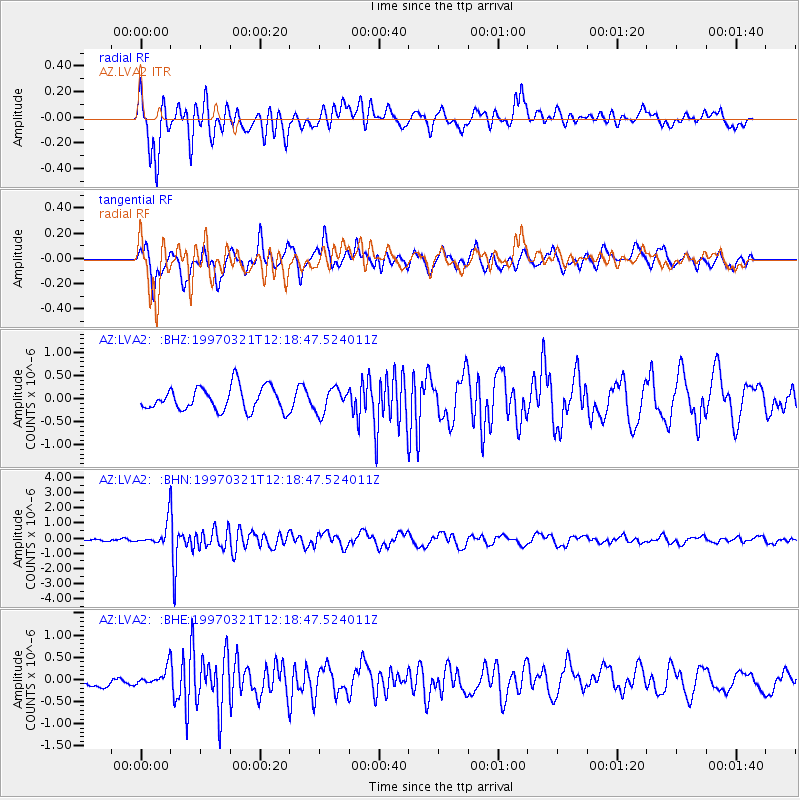
LVA2 AZ.LVA2 - Earthquake Result Viewer
*The percent match for this event was below the threshold and hence no stack was calculated.
| Earthquake location: |
Kermadec Islands Region |
| Earthquake latitude/longitude: |
-31.2/179.6 |
| Earthquake time(UTC): |
1997/03/21 (080) 12:07:17 GMT |
| Earthquake Depth: |
449 km |
| Earthquake Magnitude: |
5.6 MB, 6.3 UNKNOWN, 6.2 MW |
| Earthquake Catalog/Contributor: |
WHDF/NEIC |
|
| Network: |
AZ ANZA Regional Network |
| Station: |
LVA2 AZ.LVA2 |
| Lat/Lon: |
33.35 N/116.56 W |
| Elevation: |
1435 m |
|
| Distance: |
88.0 deg |
| Az: |
48.725 deg |
| Baz: |
230.329 deg |
| Ray Param: |
$rayparam |
*The percent match for this event was below the threshold and hence was not used in the summary stack. |
|
| Radial Match: |
75.92579 % |
| Radial Bump: |
400 |
| Transverse Match: |
68.83767 % |
| Transverse Bump: |
400 |
| SOD ConfigId: |
4480 |
| Insert Time: |
2010-02-26 19:52:31.181 +0000 |
| GWidth: |
2.5 |
| Max Bumps: |
400 |
| Tol: |
0.001 |
|
Signal To Noise
| Channel | StoN | STA | LTA |
| AZ:LVA2: :BHN:19970321T12:18:47.524011Z | 3.1869307 | 7.5720976E-7 | 2.3759844E-7 |
| AZ:LVA2: :BHE:19970321T12:18:47.524011Z | 1.5986642 | 2.066261E-7 | 1.2924923E-7 |
| AZ:LVA2: :BHZ:19970321T12:18:47.524011Z | 1.0317938 | 2.618533E-7 | 2.5378452E-7 |
| Arrivals |
| Ps | |
| PpPs | |
| PsPs/PpSs | |


