You are here: Home > Network List > TA - USArray Transportable Network (new EarthScope stations) Stations List
> Station N23A Red Feather Lakes, CO, USA > Earthquake Result Viewer
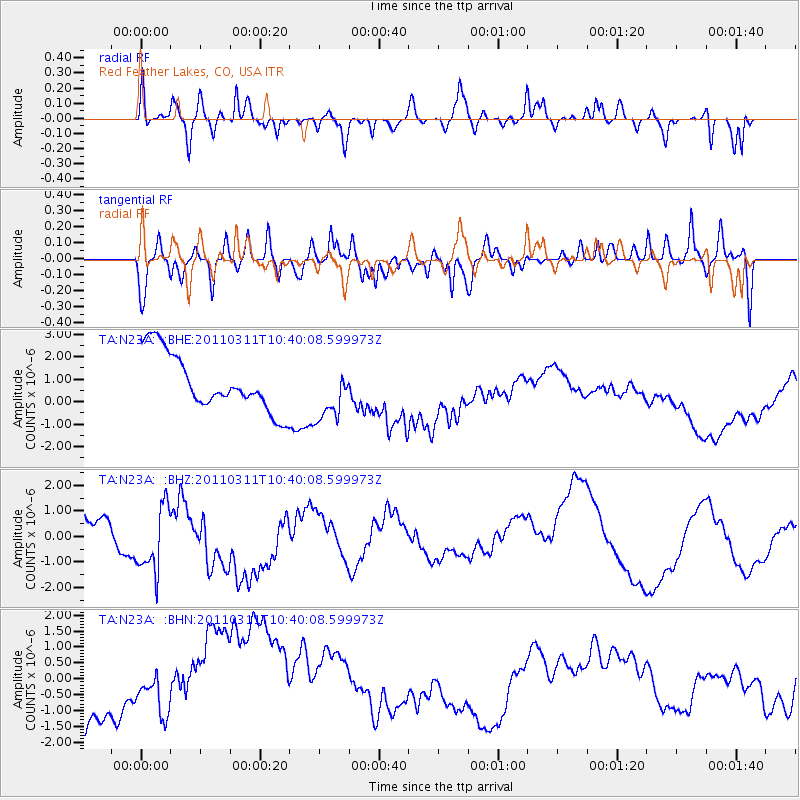
N23A Red Feather Lakes, CO, USA - Earthquake Result Viewer
*The percent match for this event was below the threshold and hence no stack was calculated.
| Earthquake location: |
Off East Coast Of Honshu, Japan |
| Earthquake latitude/longitude: |
39.4/143.6 |
| Earthquake time(UTC): |
2011/03/11 (070) 10:28:42 GMT |
| Earthquake Depth: |
20 km |
| Earthquake Magnitude: |
5.9 MB |
| Earthquake Catalog/Contributor: |
WHDF/NEIC |
|
| Network: |
TA USArray Transportable Network (new EarthScope stations) |
| Station: |
N23A Red Feather Lakes, CO, USA |
| Lat/Lon: |
40.89 N/105.94 W |
| Elevation: |
2458 m |
|
| Distance: |
78.1 deg |
| Az: |
46.548 deg |
| Baz: |
312.097 deg |
| Ray Param: |
$rayparam |
*The percent match for this event was below the threshold and hence was not used in the summary stack. |
|
| Radial Match: |
58.941628 % |
| Radial Bump: |
400 |
| Transverse Match: |
57.28202 % |
| Transverse Bump: |
400 |
| SOD ConfigId: |
356183 |
| Insert Time: |
2011-08-14 10:38:05.983 +0000 |
| GWidth: |
2.5 |
| Max Bumps: |
400 |
| Tol: |
0.001 |
|
Signal To Noise
| Channel | StoN | STA | LTA |
| TA:N23A: :BHZ:20110311T10:40:08.599973Z | 3.252696 | 1.6582475E-6 | 5.098071E-7 |
| TA:N23A: :BHN:20110311T10:40:08.599973Z | 0.3729825 | 5.2304534E-7 | 1.4023321E-6 |
| TA:N23A: :BHE:20110311T10:40:08.599973Z | 0.98385864 | 1.2354092E-6 | 1.2556775E-6 |
| Arrivals |
| Ps | |
| PpPs | |
| PsPs/PpSs | |


