You are here: Home > Network List > TA - USArray Transportable Network (new EarthScope stations) Stations List
> Station H27A Howes, SD, USA > Earthquake Result Viewer
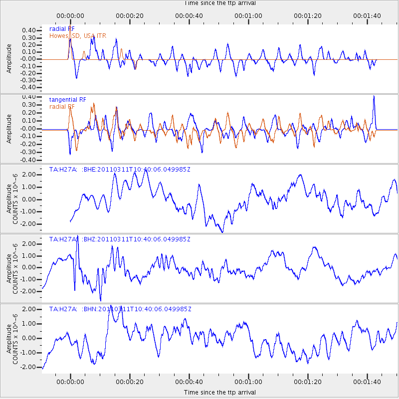
H27A Howes, SD, USA - Earthquake Result Viewer
*The percent match for this event was below the threshold and hence no stack was calculated.
| Earthquake location: |
Off East Coast Of Honshu, Japan |
| Earthquake latitude/longitude: |
39.4/143.6 |
| Earthquake time(UTC): |
2011/03/11 (070) 10:28:42 GMT |
| Earthquake Depth: |
20 km |
| Earthquake Magnitude: |
5.9 MB |
| Earthquake Catalog/Contributor: |
WHDF/NEIC |
|
| Network: |
TA USArray Transportable Network (new EarthScope stations) |
| Station: |
H27A Howes, SD, USA |
| Lat/Lon: |
44.63 N/102.08 W |
| Elevation: |
748 m |
|
| Distance: |
77.6 deg |
| Az: |
41.766 deg |
| Baz: |
313.707 deg |
| Ray Param: |
$rayparam |
*The percent match for this event was below the threshold and hence was not used in the summary stack. |
|
| Radial Match: |
69.64008 % |
| Radial Bump: |
400 |
| Transverse Match: |
41.10202 % |
| Transverse Bump: |
400 |
| SOD ConfigId: |
356183 |
| Insert Time: |
2011-08-14 10:44:22.399 +0000 |
| GWidth: |
2.5 |
| Max Bumps: |
400 |
| Tol: |
0.001 |
|
Signal To Noise
| Channel | StoN | STA | LTA |
| TA:H27A: :BHZ:20110311T10:40:06.049985Z | 0.8288831 | 1.1693096E-6 | 1.4107052E-6 |
| TA:H27A: :BHN:20110311T10:40:06.049985Z | 0.562237 | 5.692547E-7 | 1.0124818E-6 |
| TA:H27A: :BHE:20110311T10:40:06.049985Z | 0.5092586 | 5.083427E-7 | 9.982015E-7 |
| Arrivals |
| Ps | |
| PpPs | |
| PsPs/PpSs | |


