You are here: Home > Network List > TA - USArray Transportable Network (new EarthScope stations) Stations List
> Station K35A Storm Lake, IA, USA > Earthquake Result Viewer
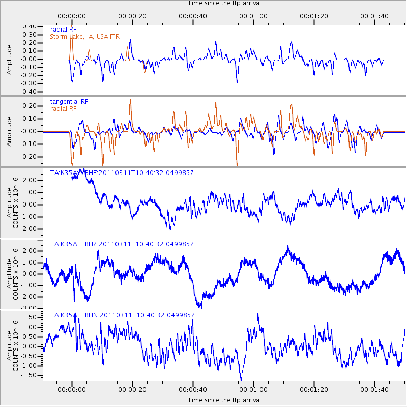
K35A Storm Lake, IA, USA - Earthquake Result Viewer
*The percent match for this event was below the threshold and hence no stack was calculated.
| Earthquake location: |
Off East Coast Of Honshu, Japan |
| Earthquake latitude/longitude: |
39.4/143.6 |
| Earthquake time(UTC): |
2011/03/11 (070) 10:28:42 GMT |
| Earthquake Depth: |
20 km |
| Earthquake Magnitude: |
5.9 MB |
| Earthquake Catalog/Contributor: |
WHDF/NEIC |
|
| Network: |
TA USArray Transportable Network (new EarthScope stations) |
| Station: |
K35A Storm Lake, IA, USA |
| Lat/Lon: |
42.72 N/95.23 W |
| Elevation: |
439 m |
|
| Distance: |
82.4 deg |
| Az: |
39.498 deg |
| Baz: |
318.027 deg |
| Ray Param: |
$rayparam |
*The percent match for this event was below the threshold and hence was not used in the summary stack. |
|
| Radial Match: |
64.30963 % |
| Radial Bump: |
365 |
| Transverse Match: |
42.818447 % |
| Transverse Bump: |
400 |
| SOD ConfigId: |
356183 |
| Insert Time: |
2011-08-14 11:27:42.275 +0000 |
| GWidth: |
2.5 |
| Max Bumps: |
400 |
| Tol: |
0.001 |
|
Signal To Noise
| Channel | StoN | STA | LTA |
| TA:K35A: :BHZ:20110311T10:40:32.049985Z | 0.8003572 | 9.080809E-7 | 1.1345944E-6 |
| TA:K35A: :BHN:20110311T10:40:32.049985Z | 1.8243637 | 1.9145177E-6 | 1.0494166E-6 |
| TA:K35A: :BHE:20110311T10:40:32.049985Z | 1.7675315 | 1.93335E-6 | 1.0938135E-6 |
| Arrivals |
| Ps | |
| PpPs | |
| PsPs/PpSs | |


