You are here: Home > Network List > TA - USArray Transportable Network (new EarthScope stations) Stations List
> Station L37A Phoenix Point, Boone, IA, USA > Earthquake Result Viewer
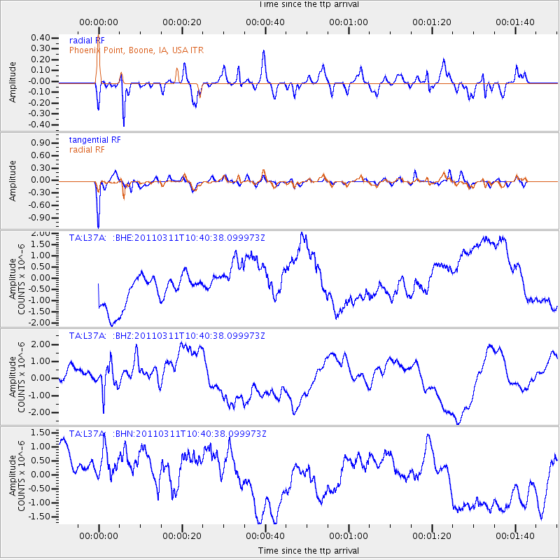
L37A Phoenix Point, Boone, IA, USA - Earthquake Result Viewer
*The percent match for this event was below the threshold and hence no stack was calculated.
| Earthquake location: |
Off East Coast Of Honshu, Japan |
| Earthquake latitude/longitude: |
39.4/143.6 |
| Earthquake time(UTC): |
2011/03/11 (070) 10:28:42 GMT |
| Earthquake Depth: |
20 km |
| Earthquake Magnitude: |
5.9 MB |
| Earthquake Catalog/Contributor: |
WHDF/NEIC |
|
| Network: |
TA USArray Transportable Network (new EarthScope stations) |
| Station: |
L37A Phoenix Point, Boone, IA, USA |
| Lat/Lon: |
42.12 N/93.75 W |
| Elevation: |
312 m |
|
| Distance: |
83.6 deg |
| Az: |
39.07 deg |
| Baz: |
318.968 deg |
| Ray Param: |
$rayparam |
*The percent match for this event was below the threshold and hence was not used in the summary stack. |
|
| Radial Match: |
60.79613 % |
| Radial Bump: |
400 |
| Transverse Match: |
76.04095 % |
| Transverse Bump: |
400 |
| SOD ConfigId: |
356183 |
| Insert Time: |
2011-08-14 11:45:19.640 +0000 |
| GWidth: |
2.5 |
| Max Bumps: |
400 |
| Tol: |
0.001 |
|
Signal To Noise
| Channel | StoN | STA | LTA |
| TA:L37A: :BHZ:20110311T10:40:38.099973Z | 0.6903392 | 1.3112559E-6 | 1.899437E-6 |
| TA:L37A: :BHN:20110311T10:40:38.099973Z | 0.8446299 | 2.1076432E-6 | 2.4953454E-6 |
| TA:L37A: :BHE:20110311T10:40:38.099973Z | 1.5805973 | 1.1001891E-6 | 6.9605915E-7 |
| Arrivals |
| Ps | |
| PpPs | |
| PsPs/PpSs | |


