You are here: Home > Network List > TA - USArray Transportable Network (new EarthScope stations) Stations List
> Station Y12C Blythe, CA, USA > Earthquake Result Viewer
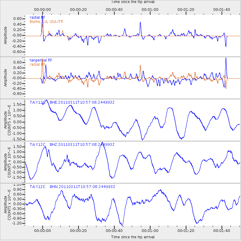
Y12C Blythe, CA, USA - Earthquake Result Viewer
*The percent match for this event was below the threshold and hence no stack was calculated.
| Earthquake location: |
Off East Coast Of Honshu, Japan |
| Earthquake latitude/longitude: |
38.4/143.8 |
| Earthquake time(UTC): |
2011/03/11 (070) 10:45:44 GMT |
| Earthquake Depth: |
33 km |
| Earthquake Magnitude: |
5.6 MB |
| Earthquake Catalog/Contributor: |
WHDF/NEIC |
|
| Network: |
TA USArray Transportable Network (new EarthScope stations) |
| Station: |
Y12C Blythe, CA, USA |
| Lat/Lon: |
33.75 N/114.52 W |
| Elevation: |
196 m |
|
| Distance: |
77.9 deg |
| Az: |
56.539 deg |
| Baz: |
308.136 deg |
| Ray Param: |
$rayparam |
*The percent match for this event was below the threshold and hence was not used in the summary stack. |
|
| Radial Match: |
52.76881 % |
| Radial Bump: |
400 |
| Transverse Match: |
41.98853 % |
| Transverse Bump: |
395 |
| SOD ConfigId: |
356183 |
| Insert Time: |
2011-08-14 13:04:40.043 +0000 |
| GWidth: |
2.5 |
| Max Bumps: |
400 |
| Tol: |
0.001 |
|
Signal To Noise
| Channel | StoN | STA | LTA |
| TA:Y12C: :BHZ:20110311T10:57:08.244993Z | 1.3171656 | 1.3600368E-6 | 1.032548E-6 |
| TA:Y12C: :BHN:20110311T10:57:08.244993Z | 2.3591788 | 1.1599104E-6 | 4.9165857E-7 |
| TA:Y12C: :BHE:20110311T10:57:08.244993Z | 1.6433815 | 9.051687E-7 | 5.5079647E-7 |
| Arrivals |
| Ps | |
| PpPs | |
| PsPs/PpSs | |


