You are here: Home > Network List > TA - USArray Transportable Network (new EarthScope stations) Stations List
> Station D31A Mcclaflin, Tower City, ND, USA > Earthquake Result Viewer
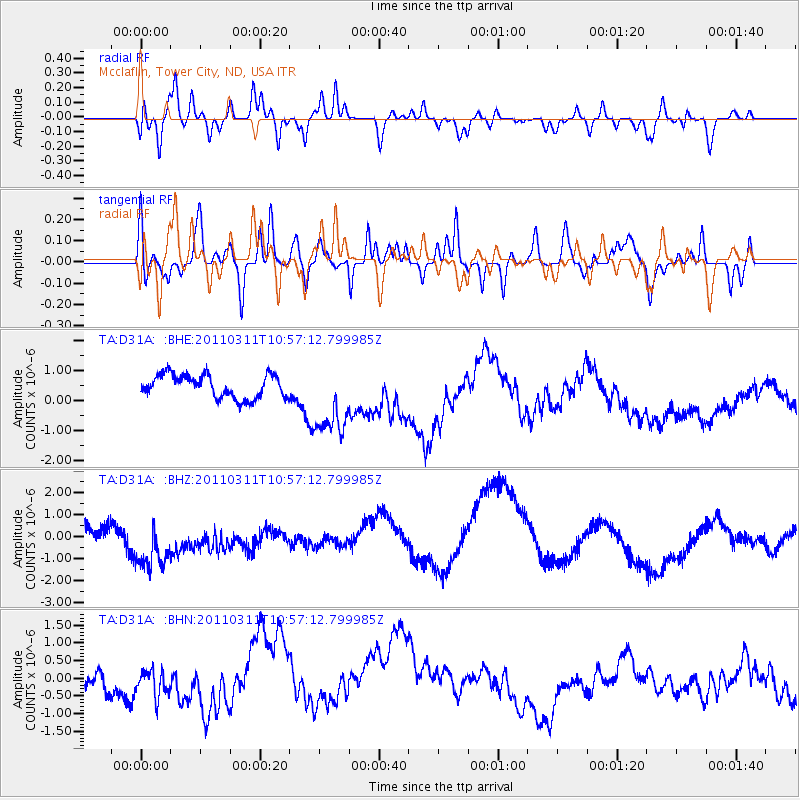
D31A Mcclaflin, Tower City, ND, USA - Earthquake Result Viewer
*The percent match for this event was below the threshold and hence no stack was calculated.
| Earthquake location: |
Off East Coast Of Honshu, Japan |
| Earthquake latitude/longitude: |
38.4/143.8 |
| Earthquake time(UTC): |
2011/03/11 (070) 10:45:44 GMT |
| Earthquake Depth: |
33 km |
| Earthquake Magnitude: |
5.6 MB |
| Earthquake Catalog/Contributor: |
WHDF/NEIC |
|
| Network: |
TA USArray Transportable Network (new EarthScope stations) |
| Station: |
D31A Mcclaflin, Tower City, ND, USA |
| Lat/Lon: |
47.05 N/97.72 W |
| Elevation: |
359 m |
|
| Distance: |
78.8 deg |
| Az: |
37.776 deg |
| Baz: |
315.277 deg |
| Ray Param: |
$rayparam |
*The percent match for this event was below the threshold and hence was not used in the summary stack. |
|
| Radial Match: |
27.318258 % |
| Radial Bump: |
400 |
| Transverse Match: |
35.750717 % |
| Transverse Bump: |
400 |
| SOD ConfigId: |
356183 |
| Insert Time: |
2011-08-14 13:54:38.129 +0000 |
| GWidth: |
2.5 |
| Max Bumps: |
400 |
| Tol: |
0.001 |
|
Signal To Noise
| Channel | StoN | STA | LTA |
| TA:D31A: :BHZ:20110311T10:57:12.799985Z | 2.1941686 | 1.3409538E-6 | 6.111444E-7 |
| TA:D31A: :BHN:20110311T10:57:12.799985Z | 1.069483 | 3.5975128E-7 | 3.3637866E-7 |
| TA:D31A: :BHE:20110311T10:57:12.799985Z | 3.3423116 | 1.288674E-6 | 3.8556368E-7 |
| Arrivals |
| Ps | |
| PpPs | |
| PsPs/PpSs | |


