You are here: Home > Network List > TA - USArray Transportable Network (new EarthScope stations) Stations List
> Station D36A Goodland, MN, USA > Earthquake Result Viewer
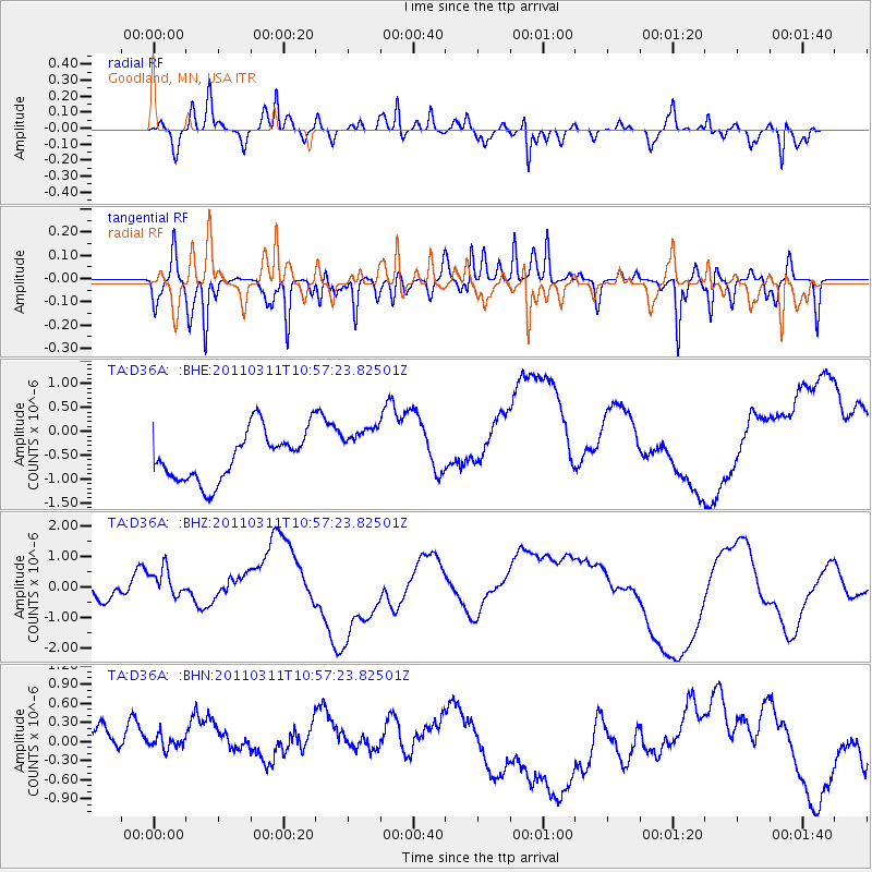
D36A Goodland, MN, USA - Earthquake Result Viewer
*The percent match for this event was below the threshold and hence no stack was calculated.
| Earthquake location: |
Off East Coast Of Honshu, Japan |
| Earthquake latitude/longitude: |
38.4/143.8 |
| Earthquake time(UTC): |
2011/03/11 (070) 10:45:44 GMT |
| Earthquake Depth: |
33 km |
| Earthquake Magnitude: |
5.6 MB |
| Earthquake Catalog/Contributor: |
WHDF/NEIC |
|
| Network: |
TA USArray Transportable Network (new EarthScope stations) |
| Station: |
D36A Goodland, MN, USA |
| Lat/Lon: |
47.18 N/93.16 W |
| Elevation: |
434 m |
|
| Distance: |
80.8 deg |
| Az: |
35.384 deg |
| Baz: |
318.182 deg |
| Ray Param: |
$rayparam |
*The percent match for this event was below the threshold and hence was not used in the summary stack. |
|
| Radial Match: |
56.46827 % |
| Radial Bump: |
367 |
| Transverse Match: |
48.430954 % |
| Transverse Bump: |
349 |
| SOD ConfigId: |
356183 |
| Insert Time: |
2011-08-14 13:58:15.648 +0000 |
| GWidth: |
2.5 |
| Max Bumps: |
400 |
| Tol: |
0.001 |
|
Signal To Noise
| Channel | StoN | STA | LTA |
| TA:D36A: :BHZ:20110311T10:57:23.82501Z | 1.0698402 | 8.8749397E-7 | 8.295575E-7 |
| TA:D36A: :BHN:20110311T10:57:23.82501Z | 0.6826996 | 5.720566E-7 | 8.379331E-7 |
| TA:D36A: :BHE:20110311T10:57:23.82501Z | 0.9824891 | 5.0910444E-7 | 5.181782E-7 |
| Arrivals |
| Ps | |
| PpPs | |
| PsPs/PpSs | |


