You are here: Home > Network List > TA - USArray Transportable Network (new EarthScope stations) Stations List
> Station G35A Watkins, MN, USA > Earthquake Result Viewer
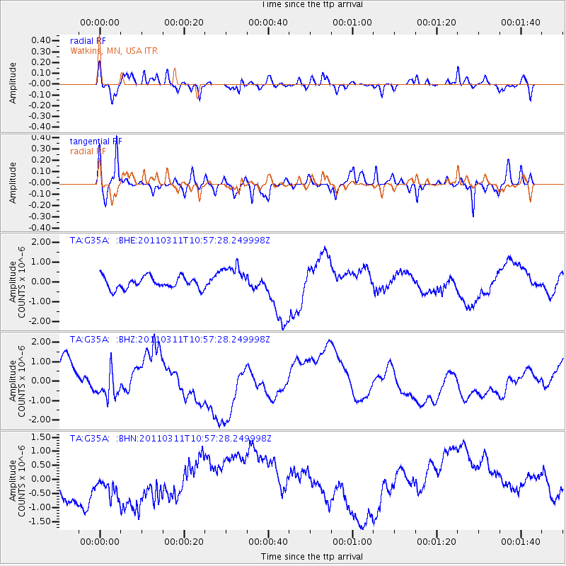
G35A Watkins, MN, USA - Earthquake Result Viewer
*The percent match for this event was below the threshold and hence no stack was calculated.
| Earthquake location: |
Off East Coast Of Honshu, Japan |
| Earthquake latitude/longitude: |
38.4/143.8 |
| Earthquake time(UTC): |
2011/03/11 (070) 10:45:44 GMT |
| Earthquake Depth: |
33 km |
| Earthquake Magnitude: |
5.6 MB |
| Earthquake Catalog/Contributor: |
WHDF/NEIC |
|
| Network: |
TA USArray Transportable Network (new EarthScope stations) |
| Station: |
G35A Watkins, MN, USA |
| Lat/Lon: |
45.22 N/94.49 W |
| Elevation: |
361 m |
|
| Distance: |
81.6 deg |
| Az: |
37.401 deg |
| Baz: |
317.54 deg |
| Ray Param: |
$rayparam |
*The percent match for this event was below the threshold and hence was not used in the summary stack. |
|
| Radial Match: |
68.48016 % |
| Radial Bump: |
400 |
| Transverse Match: |
70.91984 % |
| Transverse Bump: |
342 |
| SOD ConfigId: |
356183 |
| Insert Time: |
2011-08-14 14:00:38.759 +0000 |
| GWidth: |
2.5 |
| Max Bumps: |
400 |
| Tol: |
0.001 |
|
Signal To Noise
| Channel | StoN | STA | LTA |
| TA:G35A: :BHZ:20110311T10:57:28.249998Z | 0.38118115 | 6.02491E-7 | 1.5805897E-6 |
| TA:G35A: :BHN:20110311T10:57:28.249998Z | 1.20047 | 7.117923E-7 | 5.929281E-7 |
| TA:G35A: :BHE:20110311T10:57:28.249998Z | 2.3273234 | 6.880761E-7 | 2.9565126E-7 |
| Arrivals |
| Ps | |
| PpPs | |
| PsPs/PpSs | |


