You are here: Home > Network List > UW - Pacific Northwest Regional Seismic Network Stations List
> Station MRBL Marblemount, WA, USA > Earthquake Result Viewer
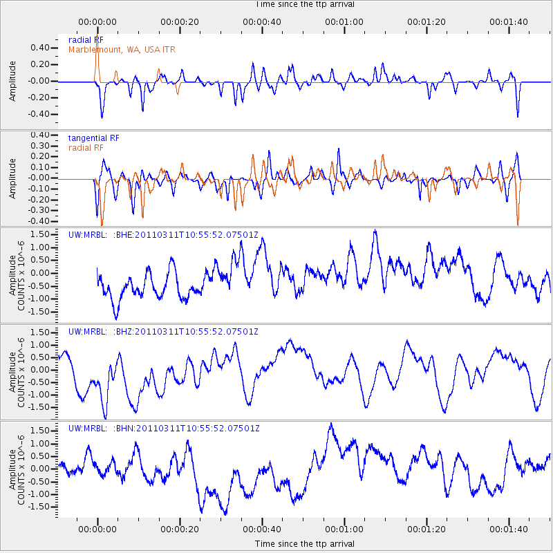
MRBL Marblemount, WA, USA - Earthquake Result Viewer
*The percent match for this event was below the threshold and hence no stack was calculated.
| Earthquake location: |
Off East Coast Of Honshu, Japan |
| Earthquake latitude/longitude: |
38.4/143.8 |
| Earthquake time(UTC): |
2011/03/11 (070) 10:45:44 GMT |
| Earthquake Depth: |
33 km |
| Earthquake Magnitude: |
5.6 MB |
| Earthquake Catalog/Contributor: |
WHDF/NEIC |
|
| Network: |
UW Pacific Northwest Regional Seismic Network |
| Station: |
MRBL Marblemount, WA, USA |
| Lat/Lon: |
48.52 N/121.48 W |
| Elevation: |
75 m |
|
| Distance: |
65.2 deg |
| Az: |
46.859 deg |
| Baz: |
300.448 deg |
| Ray Param: |
$rayparam |
*The percent match for this event was below the threshold and hence was not used in the summary stack. |
|
| Radial Match: |
70.11795 % |
| Radial Bump: |
400 |
| Transverse Match: |
50.811394 % |
| Transverse Bump: |
400 |
| SOD ConfigId: |
356183 |
| Insert Time: |
2011-08-14 14:23:02.156 +0000 |
| GWidth: |
2.5 |
| Max Bumps: |
400 |
| Tol: |
0.001 |
|
Signal To Noise
| Channel | StoN | STA | LTA |
| UW:MRBL: :BHZ:20110311T10:55:52.07501Z | 4.1574125 | 1.6626992E-6 | 3.999361E-7 |
| UW:MRBL: :BHN:20110311T10:55:52.07501Z | 1.5061448 | 7.6062156E-7 | 5.050122E-7 |
| UW:MRBL: :BHE:20110311T10:55:52.07501Z | 1.9022869 | 8.987601E-7 | 4.7246297E-7 |
| Arrivals |
| Ps | |
| PpPs | |
| PsPs/PpSs | |


