You are here: Home > Network List > AZ - ANZA Regional Network Stations List
> Station LVA2 AZ.LVA2 > Earthquake Result Viewer
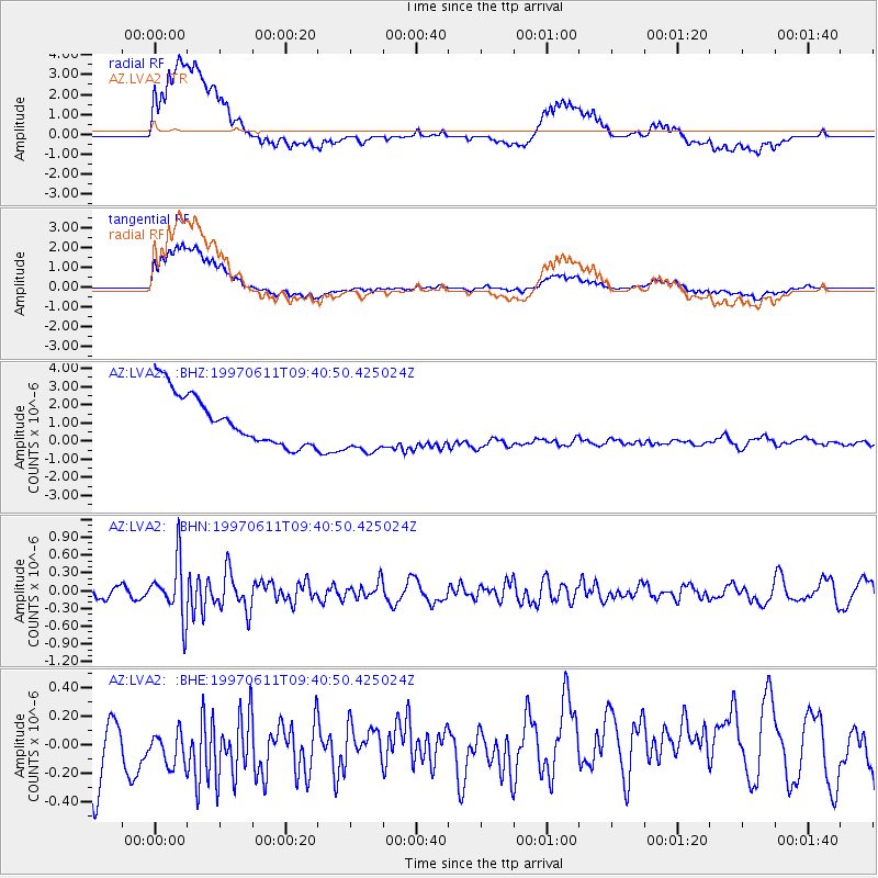
LVA2 AZ.LVA2 - Earthquake Result Viewer
*The percent match for this event was below the threshold and hence no stack was calculated.
| Earthquake location: |
South Of Fiji Islands |
| Earthquake latitude/longitude: |
-24.0/-177.5 |
| Earthquake time(UTC): |
1997/06/11 (162) 09:29:23 GMT |
| Earthquake Depth: |
164 km |
| Earthquake Magnitude: |
5.9 UNKNOWN, 5.4 MB, 5.5 MB |
| Earthquake Catalog/Contributor: |
WHDF/NEIC |
|
| Network: |
AZ ANZA Regional Network |
| Station: |
LVA2 AZ.LVA2 |
| Lat/Lon: |
33.35 N/116.56 W |
| Elevation: |
1435 m |
|
| Distance: |
81.3 deg |
| Az: |
47.744 deg |
| Baz: |
233.99 deg |
| Ray Param: |
$rayparam |
*The percent match for this event was below the threshold and hence was not used in the summary stack. |
|
| Radial Match: |
65.71823 % |
| Radial Bump: |
400 |
| Transverse Match: |
66.69387 % |
| Transverse Bump: |
400 |
| SOD ConfigId: |
4480 |
| Insert Time: |
2010-02-26 19:53:22.277 +0000 |
| GWidth: |
2.5 |
| Max Bumps: |
400 |
| Tol: |
0.001 |
|
Signal To Noise
| Channel | StoN | STA | LTA |
| AZ:LVA2: :BHN:19970611T09:40:50.425024Z | 4.446845 | 4.701052E-7 | 1.05716566E-7 |
| AZ:LVA2: :BHE:19970611T09:40:50.425024Z | 0.9016501 | 2.784482E-7 | 3.088207E-7 |
| AZ:LVA2: :BHZ:19970611T09:40:50.425024Z | 1.1149396 | 1.5371952E-6 | 1.3787251E-6 |
| Arrivals |
| Ps | |
| PpPs | |
| PsPs/PpSs | |


