You are here: Home > Network List > CN - Canadian National Seismograph Network Stations List
> Station INK INUVIK, NT > Earthquake Result Viewer
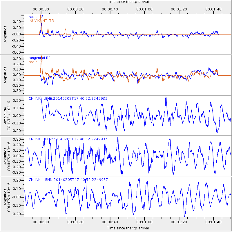
INK INUVIK, NT - Earthquake Result Viewer
*The percent match for this event was below the threshold and hence no stack was calculated.
| Earthquake location: |
Near East Coast Of Honshu, Japan |
| Earthquake latitude/longitude: |
38.7/142.4 |
| Earthquake time(UTC): |
2014/02/05 (036) 17:32:13 GMT |
| Earthquake Depth: |
46 km |
| Earthquake Magnitude: |
5.3 MW |
| Earthquake Catalog/Contributor: |
ISC/ISC |
|
| Network: |
CN Canadian National Seismograph Network |
| Station: |
INK INUVIK, NT |
| Lat/Lon: |
68.31 N/133.53 W |
| Elevation: |
44 m |
|
| Distance: |
52.6 deg |
| Az: |
27.757 deg |
| Baz: |
281.411 deg |
| Ray Param: |
$rayparam |
*The percent match for this event was below the threshold and hence was not used in the summary stack. |
|
| Radial Match: |
52.974564 % |
| Radial Bump: |
400 |
| Transverse Match: |
37.185608 % |
| Transverse Bump: |
400 |
| SOD ConfigId: |
3390531 |
| Insert Time: |
2019-04-10 06:01:40.211 +0000 |
| GWidth: |
2.5 |
| Max Bumps: |
400 |
| Tol: |
0.001 |
|
Signal To Noise
| Channel | StoN | STA | LTA |
| CN:INK: :BHZ:20140205T17:40:52.224993Z | 1.59521 | 1.8619126E-7 | 1.1671897E-7 |
| CN:INK: :BHN:20140205T17:40:52.224993Z | 0.44158754 | 4.0911353E-8 | 9.264607E-8 |
| CN:INK: :BHE:20140205T17:40:52.224993Z | 1.0341082 | 8.3359275E-8 | 8.060982E-8 |
| Arrivals |
| Ps | |
| PpPs | |
| PsPs/PpSs | |


