You are here: Home > Network List > TA - USArray Transportable Network (new EarthScope stations) Stations List
> Station U30A WK&E Inc., Balko, OK, USA > Earthquake Result Viewer
U30A WK&E Inc., Balko, OK, USA - Earthquake Result Viewer
| Earthquake location: |
Near East Coast Of Honshu, Japan |
| Earthquake latitude/longitude: |
37.7/141.5 |
| Earthquake time(UTC): |
2011/03/11 (070) 11:00:52 GMT |
| Earthquake Depth: |
42 km |
| Earthquake Magnitude: |
5.6 MB |
| Earthquake Catalog/Contributor: |
WHDF/NEIC |
|
| Network: |
TA USArray Transportable Network (new EarthScope stations) |
| Station: |
U30A WK&E Inc., Balko, OK, USA |
| Lat/Lon: |
36.53 N/100.65 W |
| Elevation: |
881 m |
|
| Distance: |
86.4 deg |
| Az: |
45.524 deg |
| Baz: |
315.384 deg |
| Ray Param: |
0.04401971 |
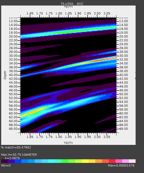
| Estimated Moho Depth: |
30.75 km |
| Estimated Crust Vp/Vs: |
2.10 |
| Assumed Crust Vp: |
6.483 km/s |
| Estimated Crust Vs: |
3.091 km/s |
| Estimated Crust Poisson's Ratio: |
0.35 |
|
| Radial Match: |
85.47982 % |
| Radial Bump: |
230 |
| Transverse Match: |
44.00293 % |
| Transverse Bump: |
217 |
| SOD ConfigId: |
356183 |
| Insert Time: |
2011-08-14 15:33:21.870 +0000 |
| GWidth: |
2.5 |
| Max Bumps: |
400 |
| Tol: |
0.001 |
|

Signal To Noise
| Channel | StoN | STA | LTA |
| TA:U30A: :BHZ:20110311T11:12:59.175005Z | 0.88582534 | 1.9027702E-6 | 2.1480196E-6 |
| TA:U30A: :BHN:20110311T11:12:59.175005Z | 0.9405476 | 7.0946925E-7 | 7.5431507E-7 |
| TA:U30A: :BHE:20110311T11:12:59.175005Z | 0.8649868 | 3.1367172E-6 | 3.626318E-6 |
| Arrivals |
| Ps | 5.3 SECOND |
| PpPs | 14 SECOND |
| PsPs/PpSs | 20 SECOND |


