You are here: Home > Network List > TA - USArray Transportable Network (new EarthScope stations) Stations List
> Station T30A Plains, KS, USA > Earthquake Result Viewer
T30A Plains, KS, USA - Earthquake Result Viewer
| Earthquake location: |
Near East Coast Of Honshu, Japan |
| Earthquake latitude/longitude: |
37.7/141.5 |
| Earthquake time(UTC): |
2011/03/11 (070) 11:00:52 GMT |
| Earthquake Depth: |
42 km |
| Earthquake Magnitude: |
5.6 MB |
| Earthquake Catalog/Contributor: |
WHDF/NEIC |
|
| Network: |
TA USArray Transportable Network (new EarthScope stations) |
| Station: |
T30A Plains, KS, USA |
| Lat/Lon: |
37.05 N/100.53 W |
| Elevation: |
778 m |
|
| Distance: |
86.1 deg |
| Az: |
45.087 deg |
| Baz: |
315.429 deg |
| Ray Param: |
0.044233304 |
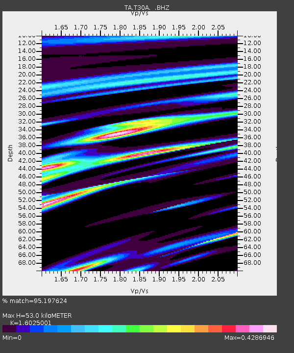
| Estimated Moho Depth: |
53.0 km |
| Estimated Crust Vp/Vs: |
1.60 |
| Assumed Crust Vp: |
6.483 km/s |
| Estimated Crust Vs: |
4.045 km/s |
| Estimated Crust Poisson's Ratio: |
0.18 |
|
| Radial Match: |
95.197624 % |
| Radial Bump: |
329 |
| Transverse Match: |
68.22394 % |
| Transverse Bump: |
263 |
| SOD ConfigId: |
356183 |
| Insert Time: |
2011-08-14 15:34:03.471 +0000 |
| GWidth: |
2.5 |
| Max Bumps: |
400 |
| Tol: |
0.001 |
|

Signal To Noise
| Channel | StoN | STA | LTA |
| TA:T30A: :BHZ:20110311T11:12:57.700029Z | 1.0762113 | 2.7882857E-6 | 2.5908346E-6 |
| TA:T30A: :BHN:20110311T11:12:57.700029Z | 0.5856395 | 3.6216616E-7 | 6.1841143E-7 |
| TA:T30A: :BHE:20110311T11:12:57.700029Z | 0.7887853 | 2.96457E-6 | 3.7583993E-6 |
| Arrivals |
| Ps | 5.1 SECOND |
| PpPs | 21 SECOND |
| PsPs/PpSs | 26 SECOND |


