You are here: Home > Network List > TA - USArray Transportable Network (new EarthScope stations) Stations List
> Station R29A Marienthal, KS, USA > Earthquake Result Viewer
R29A Marienthal, KS, USA - Earthquake Result Viewer
*The percent match for this event was below the threshold and hence no stack was calculated.
| Earthquake location: |
Near East Coast Of Honshu, Japan |
| Earthquake latitude/longitude: |
37.7/141.5 |
| Earthquake time(UTC): |
2011/03/11 (070) 11:00:52 GMT |
| Earthquake Depth: |
42 km |
| Earthquake Magnitude: |
5.6 MB |
| Earthquake Catalog/Contributor: |
WHDF/NEIC |
|
| Network: |
TA USArray Transportable Network (new EarthScope stations) |
| Station: |
R29A Marienthal, KS, USA |
| Lat/Lon: |
38.42 N/101.14 W |
| Elevation: |
957 m |
|
| Distance: |
84.8 deg |
| Az: |
44.464 deg |
| Baz: |
315.007 deg |
| Ray Param: |
$rayparam |
*The percent match for this event was below the threshold and hence was not used in the summary stack. |
|
| Radial Match: |
41.855 % |
| Radial Bump: |
264 |
| Transverse Match: |
62.338154 % |
| Transverse Bump: |
328 |
| SOD ConfigId: |
356183 |
| Insert Time: |
2011-08-14 15:34:58.837 +0000 |
| GWidth: |
2.5 |
| Max Bumps: |
400 |
| Tol: |
0.001 |
|
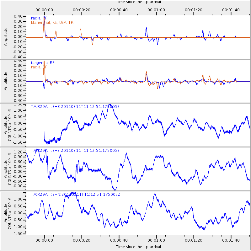
Signal To Noise
| Channel | StoN | STA | LTA |
| TA:R29A: :BHZ:20110311T11:12:51.175005Z | 0.84652543 | 2.688479E-6 | 3.1758989E-6 |
| TA:R29A: :BHN:20110311T11:12:51.175005Z | 1.1700001 | 1.1293108E-6 | 9.652229E-7 |
| TA:R29A: :BHE:20110311T11:12:51.175005Z | 2.0863636 | 1.3145689E-6 | 6.3007656E-7 |
| Arrivals |
| Ps | |
| PpPs | |
| PsPs/PpSs | |


