You are here: Home > Network List > TA - USArray Transportable Network (new EarthScope stations) Stations List
> Station 121A Cookes Peak, Deming, NM, USA > Earthquake Result Viewer
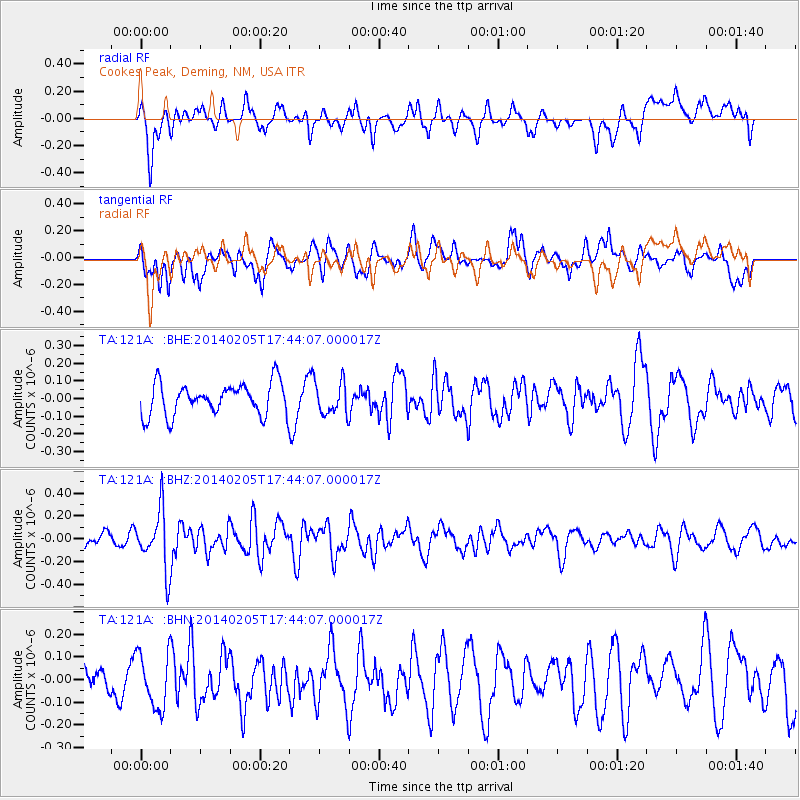
121A Cookes Peak, Deming, NM, USA - Earthquake Result Viewer
*The percent match for this event was below the threshold and hence no stack was calculated.
| Earthquake location: |
Near East Coast Of Honshu, Japan |
| Earthquake latitude/longitude: |
38.7/142.4 |
| Earthquake time(UTC): |
2014/02/05 (036) 17:32:13 GMT |
| Earthquake Depth: |
46 km |
| Earthquake Magnitude: |
5.3 MW |
| Earthquake Catalog/Contributor: |
ISC/ISC |
|
| Network: |
TA USArray Transportable Network (new EarthScope stations) |
| Station: |
121A Cookes Peak, Deming, NM, USA |
| Lat/Lon: |
32.53 N/107.79 W |
| Elevation: |
1652 m |
|
| Distance: |
83.8 deg |
| Az: |
53.053 deg |
| Baz: |
312.24 deg |
| Ray Param: |
$rayparam |
*The percent match for this event was below the threshold and hence was not used in the summary stack. |
|
| Radial Match: |
57.97891 % |
| Radial Bump: |
400 |
| Transverse Match: |
55.52111 % |
| Transverse Bump: |
400 |
| SOD ConfigId: |
3390531 |
| Insert Time: |
2019-04-10 06:04:29.368 +0000 |
| GWidth: |
2.5 |
| Max Bumps: |
400 |
| Tol: |
0.001 |
|
Signal To Noise
| Channel | StoN | STA | LTA |
| TA:121A: :BHZ:20140205T17:44:07.000017Z | 2.832349 | 2.5792522E-7 | 9.106406E-8 |
| TA:121A: :BHN:20140205T17:44:07.000017Z | 2.3641427 | 1.2082701E-7 | 5.1108174E-8 |
| TA:121A: :BHE:20140205T17:44:07.000017Z | 1.021298 | 9.240794E-8 | 9.0480874E-8 |
| Arrivals |
| Ps | |
| PpPs | |
| PsPs/PpSs | |


