You are here: Home > Network List > AZ - ANZA Regional Network Stations List
> Station LVA2 AZ.LVA2 > Earthquake Result Viewer
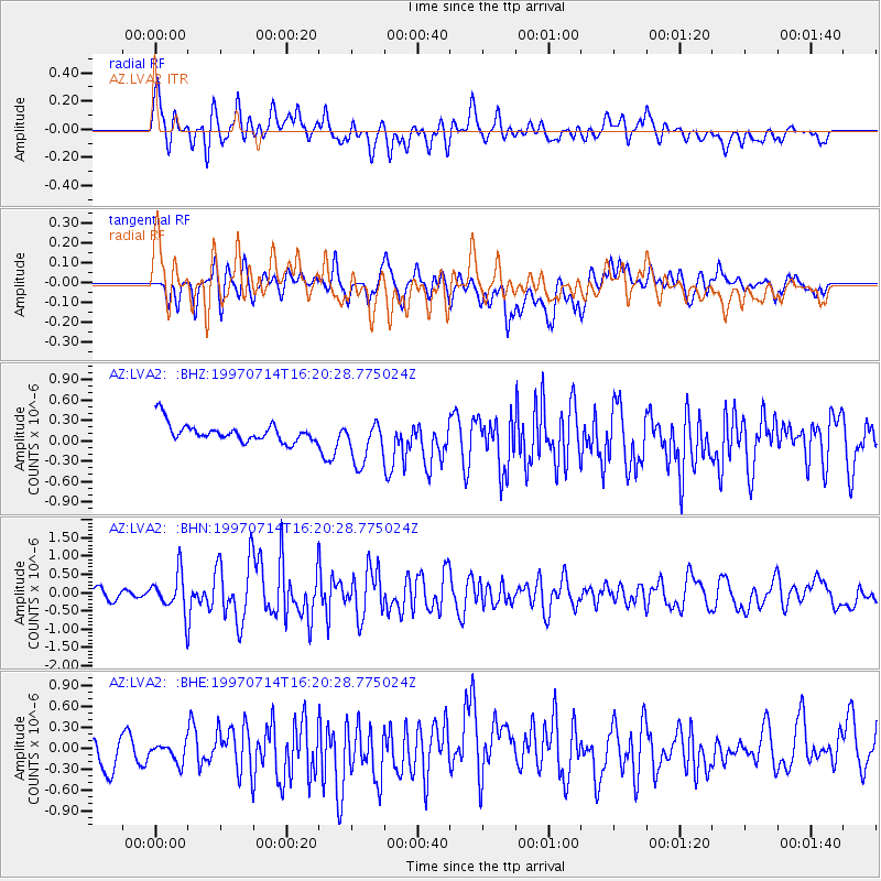
LVA2 AZ.LVA2 - Earthquake Result Viewer
*The percent match for this event was below the threshold and hence no stack was calculated.
| Earthquake location: |
Kuril Islands |
| Earthquake latitude/longitude: |
43.2/146.4 |
| Earthquake time(UTC): |
1997/07/14 (195) 16:09:35 GMT |
| Earthquake Depth: |
33 km |
| Earthquake Magnitude: |
5.9 MB, 5.8 MS, 6.1 UNKNOWN, 5.8 ME |
| Earthquake Catalog/Contributor: |
WHDF/NEIC |
|
| Network: |
AZ ANZA Regional Network |
| Station: |
LVA2 AZ.LVA2 |
| Lat/Lon: |
33.35 N/116.56 W |
| Elevation: |
1435 m |
|
| Distance: |
72.6 deg |
| Az: |
60.496 deg |
| Baz: |
310.557 deg |
| Ray Param: |
$rayparam |
*The percent match for this event was below the threshold and hence was not used in the summary stack. |
|
| Radial Match: |
68.393234 % |
| Radial Bump: |
400 |
| Transverse Match: |
59.694633 % |
| Transverse Bump: |
400 |
| SOD ConfigId: |
4480 |
| Insert Time: |
2010-02-26 19:53:46.773 +0000 |
| GWidth: |
2.5 |
| Max Bumps: |
400 |
| Tol: |
0.001 |
|
Signal To Noise
| Channel | StoN | STA | LTA |
| AZ:LVA2: :BHN:19970714T16:20:28.775024Z | 5.9012055 | 5.30372E-7 | 8.987519E-8 |
| AZ:LVA2: :BHE:19970714T16:20:28.775024Z | 0.74273366 | 2.0174191E-7 | 2.7162082E-7 |
| AZ:LVA2: :BHZ:19970714T16:20:28.775024Z | 2.3745444 | 3.2315384E-7 | 1.3609088E-7 |
| Arrivals |
| Ps | |
| PpPs | |
| PsPs/PpSs | |


