You are here: Home > Network List > TA - USArray Transportable Network (new EarthScope stations) Stations List
> Station X33A Lawton, OK, USA > Earthquake Result Viewer
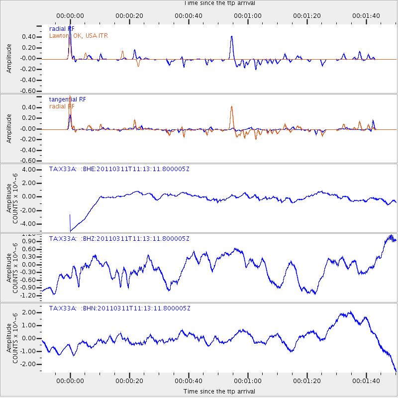
X33A Lawton, OK, USA - Earthquake Result Viewer
*The percent match for this event was below the threshold and hence no stack was calculated.
| Earthquake location: |
Near East Coast Of Honshu, Japan |
| Earthquake latitude/longitude: |
37.7/141.5 |
| Earthquake time(UTC): |
2011/03/11 (070) 11:00:52 GMT |
| Earthquake Depth: |
42 km |
| Earthquake Magnitude: |
5.6 MB |
| Earthquake Catalog/Contributor: |
WHDF/NEIC |
|
| Network: |
TA USArray Transportable Network (new EarthScope stations) |
| Station: |
X33A Lawton, OK, USA |
| Lat/Lon: |
34.54 N/98.50 W |
| Elevation: |
346 m |
|
| Distance: |
89.0 deg |
| Az: |
45.641 deg |
| Baz: |
316.633 deg |
| Ray Param: |
$rayparam |
*The percent match for this event was below the threshold and hence was not used in the summary stack. |
|
| Radial Match: |
17.323822 % |
| Radial Bump: |
169 |
| Transverse Match: |
52.508907 % |
| Transverse Bump: |
287 |
| SOD ConfigId: |
356183 |
| Insert Time: |
2011-08-14 15:51:31.552 +0000 |
| GWidth: |
2.5 |
| Max Bumps: |
400 |
| Tol: |
0.001 |
|
Signal To Noise
| Channel | StoN | STA | LTA |
| TA:X33A: :BHZ:20110311T11:13:11.800005Z | 0.77050066 | 2.2260842E-6 | 2.8891398E-6 |
| TA:X33A: :BHN:20110311T11:13:11.800005Z | 1.021448 | 1.4818869E-6 | 1.4507707E-6 |
| TA:X33A: :BHE:20110311T11:13:11.800005Z | 0.667868 | 1.2008138E-6 | 1.7979808E-6 |
| Arrivals |
| Ps | |
| PpPs | |
| PsPs/PpSs | |


