You are here: Home > Network List > TA - USArray Transportable Network (new EarthScope stations) Stations List
> Station 635A Leesville, TX, USA > Earthquake Result Viewer
635A Leesville, TX, USA - Earthquake Result Viewer
| Earthquake location: |
Near East Coast Of Honshu, Japan |
| Earthquake latitude/longitude: |
37.7/141.5 |
| Earthquake time(UTC): |
2011/03/11 (070) 11:00:52 GMT |
| Earthquake Depth: |
42 km |
| Earthquake Magnitude: |
5.6 MB |
| Earthquake Catalog/Contributor: |
WHDF/NEIC |
|
| Network: |
TA USArray Transportable Network (new EarthScope stations) |
| Station: |
635A Leesville, TX, USA |
| Lat/Lon: |
29.39 N/97.77 W |
| Elevation: |
119 m |
|
| Distance: |
93.2 deg |
| Az: |
48.708 deg |
| Baz: |
316.956 deg |
| Ray Param: |
0.04128941 |
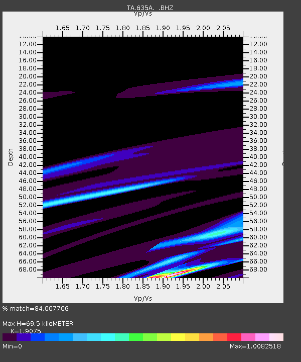
| Estimated Moho Depth: |
69.5 km |
| Estimated Crust Vp/Vs: |
1.91 |
| Assumed Crust Vp: |
5.78 km/s |
| Estimated Crust Vs: |
3.03 km/s |
| Estimated Crust Poisson's Ratio: |
0.31 |
|
| Radial Match: |
84.007706 % |
| Radial Bump: |
266 |
| Transverse Match: |
52.924408 % |
| Transverse Bump: |
371 |
| SOD ConfigId: |
356183 |
| Insert Time: |
2011-08-14 15:58:08.278 +0000 |
| GWidth: |
2.5 |
| Max Bumps: |
400 |
| Tol: |
0.001 |
|
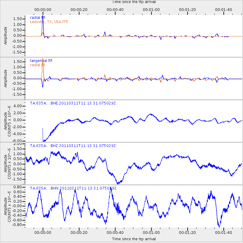
Signal To Noise
| Channel | StoN | STA | LTA |
| TA:635A: :BHZ:20110311T11:13:31.075029Z | 1.0280893 | 1.713454E-6 | 1.6666393E-6 |
| TA:635A: :BHN:20110311T11:13:31.075029Z | 0.84369326 | 8.91013E-7 | 1.0560864E-6 |
| TA:635A: :BHE:20110311T11:13:31.075029Z | 0.851164 | 1.6766311E-6 | 1.9698098E-6 |
| Arrivals |
| Ps | 11 SECOND |
| PpPs | 34 SECOND |
| PsPs/PpSs | 46 SECOND |


