You are here: Home > Network List > TA - USArray Transportable Network (new EarthScope stations) Stations List
> Station 136A Ennis, TX, USA > Earthquake Result Viewer
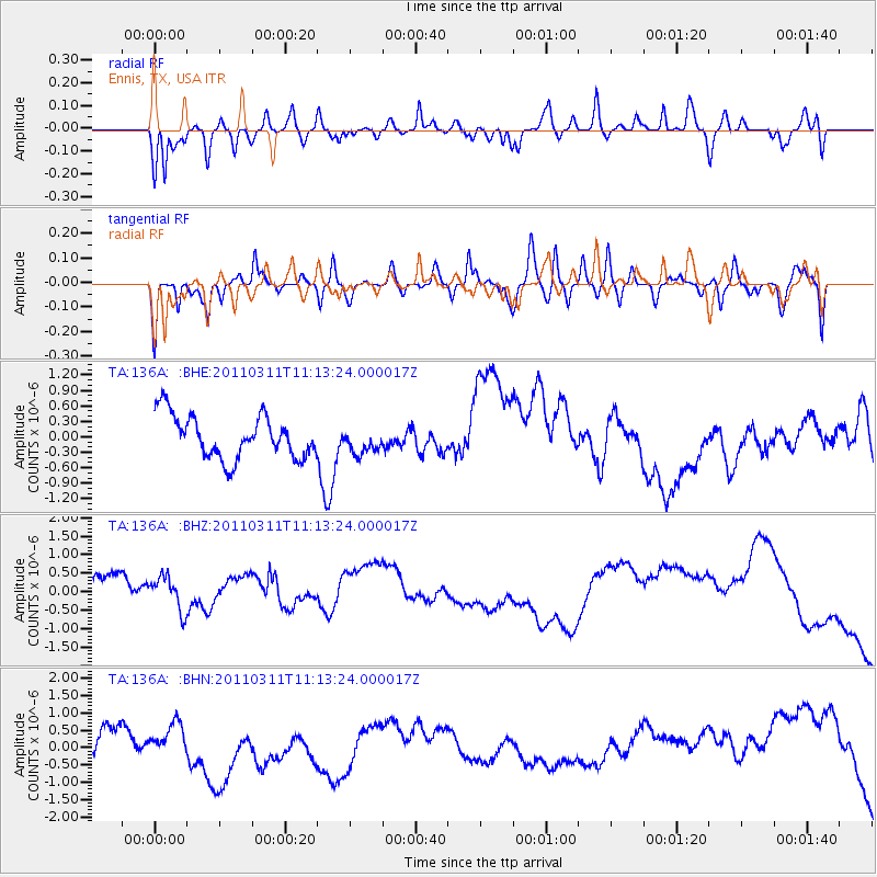
136A Ennis, TX, USA - Earthquake Result Viewer
*The percent match for this event was below the threshold and hence no stack was calculated.
| Earthquake location: |
Near East Coast Of Honshu, Japan |
| Earthquake latitude/longitude: |
37.7/141.5 |
| Earthquake time(UTC): |
2011/03/11 (070) 11:00:52 GMT |
| Earthquake Depth: |
42 km |
| Earthquake Magnitude: |
5.6 MB |
| Earthquake Catalog/Contributor: |
WHDF/NEIC |
|
| Network: |
TA USArray Transportable Network (new EarthScope stations) |
| Station: |
136A Ennis, TX, USA |
| Lat/Lon: |
32.47 N/96.53 W |
| Elevation: |
113 m |
|
| Distance: |
91.7 deg |
| Az: |
45.834 deg |
| Baz: |
317.715 deg |
| Ray Param: |
$rayparam |
*The percent match for this event was below the threshold and hence was not used in the summary stack. |
|
| Radial Match: |
64.00591 % |
| Radial Bump: |
350 |
| Transverse Match: |
56.174335 % |
| Transverse Bump: |
350 |
| SOD ConfigId: |
356183 |
| Insert Time: |
2011-08-14 16:14:01.895 +0000 |
| GWidth: |
2.5 |
| Max Bumps: |
400 |
| Tol: |
0.001 |
|
Signal To Noise
| Channel | StoN | STA | LTA |
| TA:136A: :BHZ:20110311T11:13:24.000017Z | 0.76899254 | 9.729705E-7 | 1.2652534E-6 |
| TA:136A: :BHN:20110311T11:13:24.000017Z | 1.0257208 | 4.1591576E-7 | 4.0548633E-7 |
| TA:136A: :BHE:20110311T11:13:24.000017Z | 0.5830282 | 2.4264597E-7 | 4.1618222E-7 |
| Arrivals |
| Ps | |
| PpPs | |
| PsPs/PpSs | |


