You are here: Home > Network List > X812 - Deep Structure of Three Continental Sutures in Eastern North America Stations List
> Station QM12 Camp Vic, Maine, USA > Earthquake Result Viewer
QM12 Camp Vic, Maine, USA - Earthquake Result Viewer
| Earthquake location: |
Near East Coast Of Honshu, Japan |
| Earthquake latitude/longitude: |
38.7/142.4 |
| Earthquake time(UTC): |
2014/02/05 (036) 17:32:13 GMT |
| Earthquake Depth: |
46 km |
| Earthquake Magnitude: |
5.3 MW |
| Earthquake Catalog/Contributor: |
ISC/ISC |
|
| Network: |
X8 Deep Structure of Three Continental Sutures in Eastern North America |
| Station: |
QM12 Camp Vic, Maine, USA |
| Lat/Lon: |
44.97 N/67.86 W |
| Elevation: |
15 m |
|
| Distance: |
92.4 deg |
| Az: |
20.948 deg |
| Baz: |
336.788 deg |
| Ray Param: |
0.041451883 |
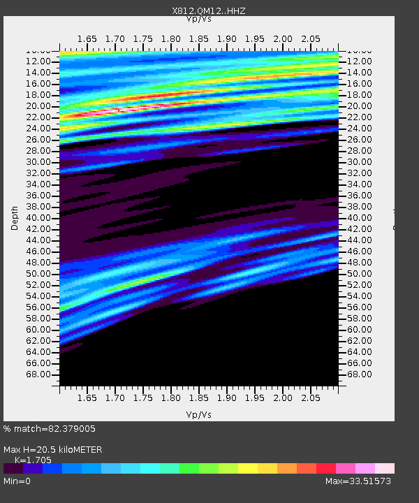
| Estimated Moho Depth: |
20.5 km |
| Estimated Crust Vp/Vs: |
1.71 |
| Assumed Crust Vp: |
6.419 km/s |
| Estimated Crust Vs: |
3.765 km/s |
| Estimated Crust Poisson's Ratio: |
0.24 |
|
| Radial Match: |
82.379005 % |
| Radial Bump: |
296 |
| Transverse Match: |
84.68283 % |
| Transverse Bump: |
320 |
| SOD ConfigId: |
3390531 |
| Insert Time: |
2019-04-10 06:06:41.761 +0000 |
| GWidth: |
2.5 |
| Max Bumps: |
400 |
| Tol: |
0.001 |
|

Signal To Noise
| Channel | StoN | STA | LTA |
| X8:QM12: :HHZ:20140205T17:44:48.175005Z | 1.1867927 | 6.9479233E-7 | 5.8543696E-7 |
| X8:QM12: :HHN:20140205T17:44:48.175005Z | 5.6579137 | 7.5421056E-5 | 1.3330189E-5 |
| X8:QM12: :HHE:20140205T17:44:48.175005Z | 2.1788223 | 1.715258E-4 | 7.8724086E-5 |
| Arrivals |
| Ps | 2.3 SECOND |
| PpPs | 8.5 SECOND |
| PsPs/PpSs | 11 SECOND |


