You are here: Home > Network List > TA - USArray Transportable Network (new EarthScope stations) Stations List
> Station F36A Milaca, MN, USA > Earthquake Result Viewer
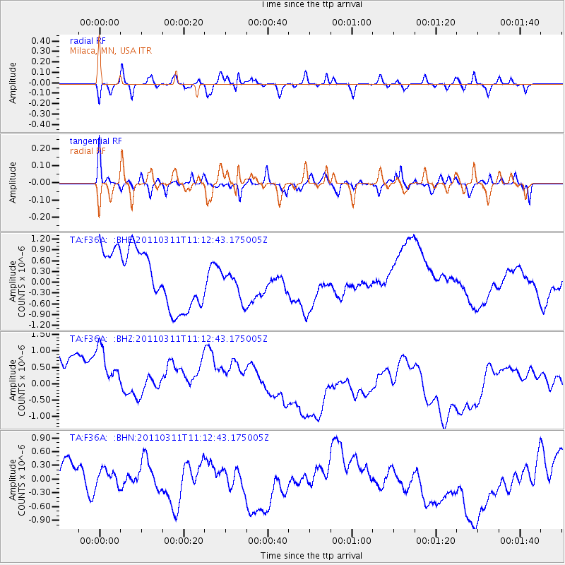
F36A Milaca, MN, USA - Earthquake Result Viewer
*The percent match for this event was below the threshold and hence no stack was calculated.
| Earthquake location: |
Near East Coast Of Honshu, Japan |
| Earthquake latitude/longitude: |
37.7/141.5 |
| Earthquake time(UTC): |
2011/03/11 (070) 11:00:52 GMT |
| Earthquake Depth: |
42 km |
| Earthquake Magnitude: |
5.6 MB |
| Earthquake Catalog/Contributor: |
WHDF/NEIC |
|
| Network: |
TA USArray Transportable Network (new EarthScope stations) |
| Station: |
F36A Milaca, MN, USA |
| Lat/Lon: |
45.86 N/93.52 W |
| Elevation: |
345 m |
|
| Distance: |
83.2 deg |
| Az: |
35.213 deg |
| Baz: |
319.142 deg |
| Ray Param: |
$rayparam |
*The percent match for this event was below the threshold and hence was not used in the summary stack. |
|
| Radial Match: |
16.84443 % |
| Radial Bump: |
281 |
| Transverse Match: |
70.560524 % |
| Transverse Bump: |
313 |
| SOD ConfigId: |
356183 |
| Insert Time: |
2011-08-14 16:27:45.572 +0000 |
| GWidth: |
2.5 |
| Max Bumps: |
400 |
| Tol: |
0.001 |
|
Signal To Noise
| Channel | StoN | STA | LTA |
| TA:F36A: :BHZ:20110311T11:12:43.175005Z | 1.0237708 | 2.5362665E-6 | 2.4773772E-6 |
| TA:F36A: :BHN:20110311T11:12:43.175005Z | 0.5223227 | 2.244995E-7 | 4.2980997E-7 |
| TA:F36A: :BHE:20110311T11:12:43.175005Z | 0.5537087 | 4.2686523E-7 | 7.709203E-7 |
| Arrivals |
| Ps | |
| PpPs | |
| PsPs/PpSs | |


