You are here: Home > Network List > TA - USArray Transportable Network (new EarthScope stations) Stations List
> Station G36A St. Michael, MN, USA > Earthquake Result Viewer
G36A St. Michael, MN, USA - Earthquake Result Viewer
*The percent match for this event was below the threshold and hence no stack was calculated.
| Earthquake location: |
Near East Coast Of Honshu, Japan |
| Earthquake latitude/longitude: |
37.7/141.5 |
| Earthquake time(UTC): |
2011/03/11 (070) 11:00:52 GMT |
| Earthquake Depth: |
42 km |
| Earthquake Magnitude: |
5.6 MB |
| Earthquake Catalog/Contributor: |
WHDF/NEIC |
|
| Network: |
TA USArray Transportable Network (new EarthScope stations) |
| Station: |
G36A St. Michael, MN, USA |
| Lat/Lon: |
45.23 N/93.75 W |
| Elevation: |
293 m |
|
| Distance: |
83.6 deg |
| Az: |
35.748 deg |
| Baz: |
319.042 deg |
| Ray Param: |
$rayparam |
*The percent match for this event was below the threshold and hence was not used in the summary stack. |
|
| Radial Match: |
11.069296 % |
| Radial Bump: |
199 |
| Transverse Match: |
71.247246 % |
| Transverse Bump: |
316 |
| SOD ConfigId: |
356183 |
| Insert Time: |
2011-08-14 16:28:12.686 +0000 |
| GWidth: |
2.5 |
| Max Bumps: |
400 |
| Tol: |
0.001 |
|
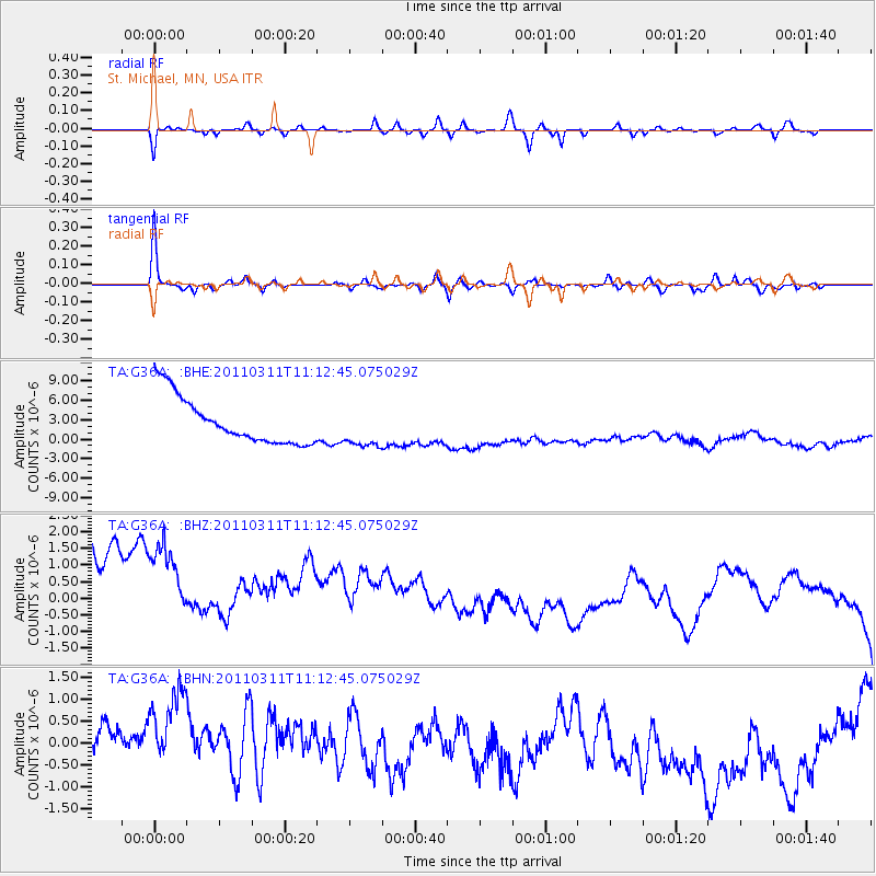
Signal To Noise
| Channel | StoN | STA | LTA |
| TA:G36A: :BHZ:20110311T11:12:45.075029Z | 0.88443285 | 5.583628E-6 | 6.31323E-6 |
| TA:G36A: :BHN:20110311T11:12:45.075029Z | 1.4466927 | 1.1934034E-6 | 8.249184E-7 |
| TA:G36A: :BHE:20110311T11:12:45.075029Z | 0.88502926 | 3.176441E-6 | 3.5890803E-6 |
| Arrivals |
| Ps | |
| PpPs | |
| PsPs/PpSs | |


