You are here: Home > Network List > TA - USArray Transportable Network (new EarthScope stations) Stations List
> Station X39A Fountain Ranch, Mena, AR, USA > Earthquake Result Viewer
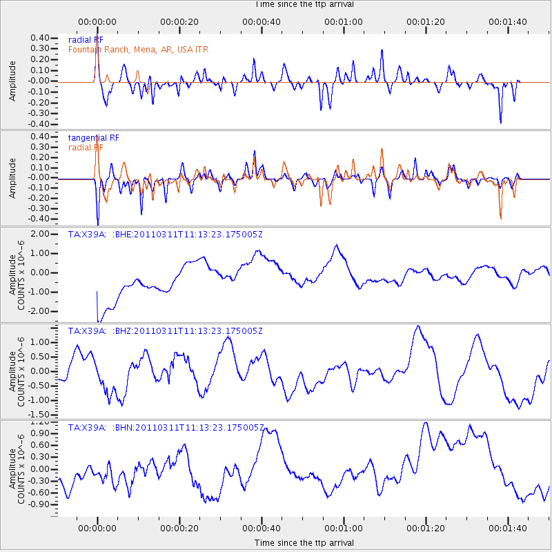
X39A Fountain Ranch, Mena, AR, USA - Earthquake Result Viewer
*The percent match for this event was below the threshold and hence no stack was calculated.
| Earthquake location: |
Near East Coast Of Honshu, Japan |
| Earthquake latitude/longitude: |
37.7/141.5 |
| Earthquake time(UTC): |
2011/03/11 (070) 11:00:52 GMT |
| Earthquake Depth: |
42 km |
| Earthquake Magnitude: |
5.6 MB |
| Earthquake Catalog/Contributor: |
WHDF/NEIC |
|
| Network: |
TA USArray Transportable Network (new EarthScope stations) |
| Station: |
X39A Fountain Ranch, Mena, AR, USA |
| Lat/Lon: |
34.51 N/94.11 W |
| Elevation: |
326 m |
|
| Distance: |
91.5 deg |
| Az: |
42.975 deg |
| Baz: |
319.121 deg |
| Ray Param: |
$rayparam |
*The percent match for this event was below the threshold and hence was not used in the summary stack. |
|
| Radial Match: |
39.261063 % |
| Radial Bump: |
351 |
| Transverse Match: |
62.72299 % |
| Transverse Bump: |
327 |
| SOD ConfigId: |
356183 |
| Insert Time: |
2011-08-14 16:44:50.565 +0000 |
| GWidth: |
2.5 |
| Max Bumps: |
400 |
| Tol: |
0.001 |
|
Signal To Noise
| Channel | StoN | STA | LTA |
| TA:X39A: :BHZ:20110311T11:13:23.175005Z | 0.44104108 | 4.8253884E-7 | 1.0940905E-6 |
| TA:X39A: :BHN:20110311T11:13:23.175005Z | 0.60790855 | 6.1109955E-7 | 1.005249E-6 |
| TA:X39A: :BHE:20110311T11:13:23.175005Z | 0.73602676 | 6.125809E-7 | 8.3228076E-7 |
| Arrivals |
| Ps | |
| PpPs | |
| PsPs/PpSs | |


