You are here: Home > Network List > US - United States National Seismic Network Stations List
> Station MIAR Mount Ida, Arkansas, USA > Earthquake Result Viewer
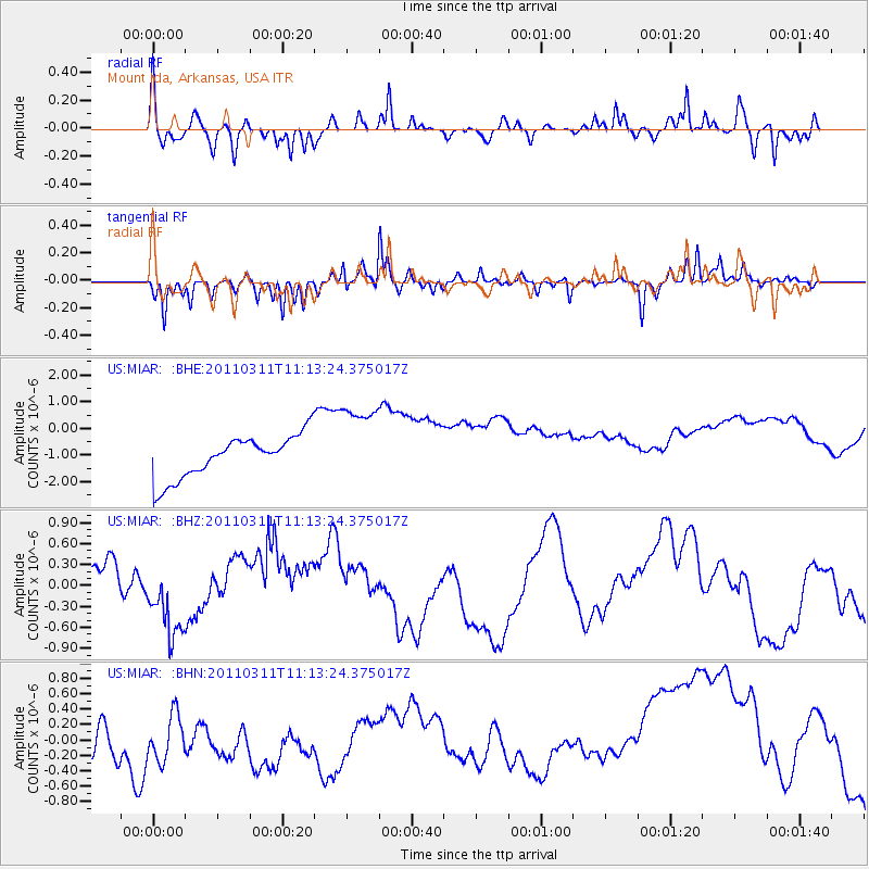
MIAR Mount Ida, Arkansas, USA - Earthquake Result Viewer
*The percent match for this event was below the threshold and hence no stack was calculated.
| Earthquake location: |
Near East Coast Of Honshu, Japan |
| Earthquake latitude/longitude: |
37.7/141.5 |
| Earthquake time(UTC): |
2011/03/11 (070) 11:00:52 GMT |
| Earthquake Depth: |
42 km |
| Earthquake Magnitude: |
5.6 MB |
| Earthquake Catalog/Contributor: |
WHDF/NEIC |
|
| Network: |
US United States National Seismic Network |
| Station: |
MIAR Mount Ida, Arkansas, USA |
| Lat/Lon: |
34.55 N/93.58 W |
| Elevation: |
207 m |
|
| Distance: |
91.8 deg |
| Az: |
42.616 deg |
| Baz: |
319.435 deg |
| Ray Param: |
$rayparam |
*The percent match for this event was below the threshold and hence was not used in the summary stack. |
|
| Radial Match: |
33.2896 % |
| Radial Bump: |
283 |
| Transverse Match: |
73.63867 % |
| Transverse Bump: |
291 |
| SOD ConfigId: |
356183 |
| Insert Time: |
2011-08-14 16:54:50.576 +0000 |
| GWidth: |
2.5 |
| Max Bumps: |
400 |
| Tol: |
0.001 |
|
Signal To Noise
| Channel | StoN | STA | LTA |
| US:MIAR: :BHZ:20110311T11:13:24.375017Z | 0.28700733 | 2.73504E-7 | 9.529513E-7 |
| US:MIAR: :BHN:20110311T11:13:24.375017Z | 0.54497474 | 4.4871678E-7 | 8.233717E-7 |
| US:MIAR: :BHE:20110311T11:13:24.375017Z | 1.9989065 | 1.594831E-6 | 7.978517E-7 |
| Arrivals |
| Ps | |
| PpPs | |
| PsPs/PpSs | |


