You are here: Home > Network List > AZ - ANZA Regional Network Stations List
> Station LVA2 AZ.LVA2 > Earthquake Result Viewer
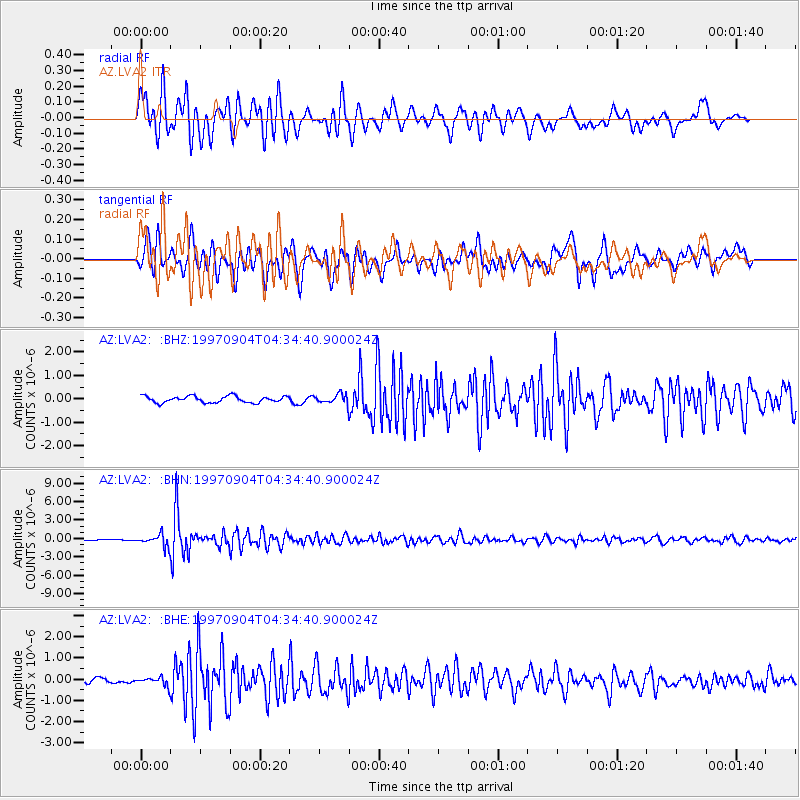
LVA2 AZ.LVA2 - Earthquake Result Viewer
*The percent match for this event was below the threshold and hence no stack was calculated.
| Earthquake location: |
South Of Fiji Islands |
| Earthquake latitude/longitude: |
-26.6/178.3 |
| Earthquake time(UTC): |
1997/09/04 (247) 04:23:37 GMT |
| Earthquake Depth: |
625 km |
| Earthquake Magnitude: |
6.3 MB, 6.8 UNKNOWN, 6.5 ME |
| Earthquake Catalog/Contributor: |
WHDF/NEIC |
|
| Network: |
AZ ANZA Regional Network |
| Station: |
LVA2 AZ.LVA2 |
| Lat/Lon: |
33.35 N/116.56 W |
| Elevation: |
1435 m |
|
| Distance: |
85.9 deg |
| Az: |
49.57 deg |
| Baz: |
234.536 deg |
| Ray Param: |
$rayparam |
*The percent match for this event was below the threshold and hence was not used in the summary stack. |
|
| Radial Match: |
85.56809 % |
| Radial Bump: |
400 |
| Transverse Match: |
81.79783 % |
| Transverse Bump: |
400 |
| SOD ConfigId: |
4480 |
| Insert Time: |
2010-02-26 19:54:15.551 +0000 |
| GWidth: |
2.5 |
| Max Bumps: |
400 |
| Tol: |
0.001 |
|
Signal To Noise
| Channel | StoN | STA | LTA |
| AZ:LVA2: :BHN:19970904T04:34:40.900024Z | 8.237612 | 9.706457E-7 | 1.1783096E-7 |
| AZ:LVA2: :BHE:19970904T04:34:40.900024Z | 1.9291545 | 2.0175646E-7 | 1.0458284E-7 |
| AZ:LVA2: :BHZ:19970904T04:34:40.900024Z | 1.4795779 | 2.0276676E-7 | 1.3704366E-7 |
| Arrivals |
| Ps | |
| PpPs | |
| PsPs/PpSs | |


