You are here: Home > Network List > CI - Caltech Regional Seismic Network Stations List
> Station FUR Furnace Creek, CA, USA > Earthquake Result Viewer
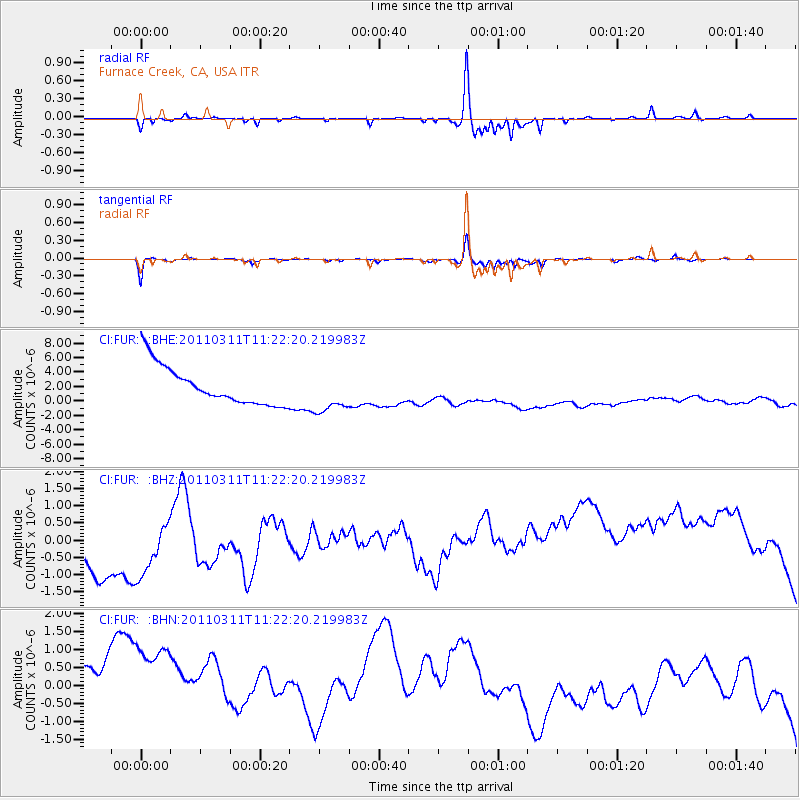
FUR Furnace Creek, CA, USA - Earthquake Result Viewer
*The percent match for this event was below the threshold and hence no stack was calculated.
| Earthquake location: |
Near East Coast Of Honshu, Japan |
| Earthquake latitude/longitude: |
35.5/141.8 |
| Earthquake time(UTC): |
2011/03/11 (070) 11:10:58 GMT |
| Earthquake Depth: |
35 km |
| Earthquake Magnitude: |
5.5 MB |
| Earthquake Catalog/Contributor: |
WHDF/NEIC |
|
| Network: |
CI Caltech Regional Seismic Network |
| Station: |
FUR Furnace Creek, CA, USA |
| Lat/Lon: |
36.47 N/116.86 W |
| Elevation: |
-37.0 m |
|
| Distance: |
77.7 deg |
| Az: |
54.015 deg |
| Baz: |
305.044 deg |
| Ray Param: |
$rayparam |
*The percent match for this event was below the threshold and hence was not used in the summary stack. |
|
| Radial Match: |
87.80994 % |
| Radial Bump: |
231 |
| Transverse Match: |
72.84368 % |
| Transverse Bump: |
249 |
| SOD ConfigId: |
356183 |
| Insert Time: |
2011-08-14 17:34:58.912 +0000 |
| GWidth: |
2.5 |
| Max Bumps: |
400 |
| Tol: |
0.001 |
|
Signal To Noise
| Channel | StoN | STA | LTA |
| CI:FUR: :BHZ:20110311T11:22:20.219983Z | 0.78550607 | 1.0331084E-6 | 1.3152138E-6 |
| CI:FUR: :BHN:20110311T11:22:20.219983Z | 1.0212713 | 3.9827046E-6 | 3.8997514E-6 |
| CI:FUR: :BHE:20110311T11:22:20.219983Z | 1.0814736 | 2.8824686E-6 | 2.6653158E-6 |
| Arrivals |
| Ps | |
| PpPs | |
| PsPs/PpSs | |


