You are here: Home > Network List > IC - New China Digital Seismograph Network Stations List
> Station KMI Kunming, Yunnan Province, China > Earthquake Result Viewer
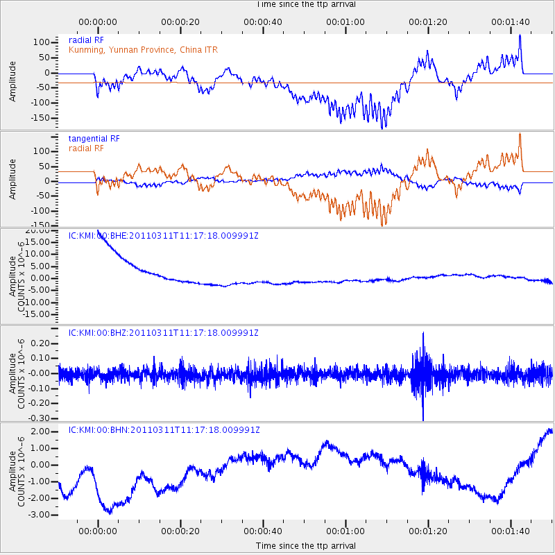
KMI Kunming, Yunnan Province, China - Earthquake Result Viewer
*The percent match for this event was below the threshold and hence no stack was calculated.
| Earthquake location: |
Near East Coast Of Honshu, Japan |
| Earthquake latitude/longitude: |
35.5/141.8 |
| Earthquake time(UTC): |
2011/03/11 (070) 11:10:58 GMT |
| Earthquake Depth: |
35 km |
| Earthquake Magnitude: |
5.5 MB |
| Earthquake Catalog/Contributor: |
WHDF/NEIC |
|
| Network: |
IC New China Digital Seismograph Network |
| Station: |
KMI Kunming, Yunnan Province, China |
| Lat/Lon: |
25.12 N/102.74 E |
| Elevation: |
1975 m |
|
| Distance: |
35.1 deg |
| Az: |
263.746 deg |
| Baz: |
63.429 deg |
| Ray Param: |
$rayparam |
*The percent match for this event was below the threshold and hence was not used in the summary stack. |
|
| Radial Match: |
68.63687 % |
| Radial Bump: |
400 |
| Transverse Match: |
65.53933 % |
| Transverse Bump: |
400 |
| SOD ConfigId: |
356183 |
| Insert Time: |
2011-08-14 17:52:16.986 +0000 |
| GWidth: |
2.5 |
| Max Bumps: |
400 |
| Tol: |
0.001 |
|
Signal To Noise
| Channel | StoN | STA | LTA |
| IC:KMI:00:BHZ:20110311T11:17:18.009991Z | 0.99572104 | 3.138268E-8 | 3.1517544E-8 |
| IC:KMI:00:BHN:20110311T11:17:18.009991Z | 1.2331158 | 6.83515E-6 | 5.5429914E-6 |
| IC:KMI:00:BHE:20110311T11:17:18.009991Z | 1.1698639 | 7.038882E-6 | 6.016838E-6 |
| Arrivals |
| Ps | |
| PpPs | |
| PsPs/PpSs | |


