You are here: Home > Network List > TA - USArray Transportable Network (new EarthScope stations) Stations List
> Station J04D Umpqua National Forest, Toketee, OR, USA > Earthquake Result Viewer
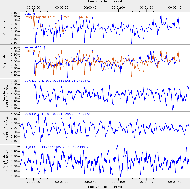
J04D Umpqua National Forest, Toketee, OR, USA - Earthquake Result Viewer
*The percent match for this event was below the threshold and hence no stack was calculated.
| Earthquake location: |
Vanuatu Islands |
| Earthquake latitude/longitude: |
-20.4/169.3 |
| Earthquake time(UTC): |
2014/02/05 (036) 22:53:05 GMT |
| Earthquake Depth: |
48 km |
| Earthquake Magnitude: |
5.5 MWB |
| Earthquake Catalog/Contributor: |
NEIC PDE/NEIC COMCAT |
|
| Network: |
TA USArray Transportable Network (new EarthScope stations) |
| Station: |
J04D Umpqua National Forest, Toketee, OR, USA |
| Lat/Lon: |
43.24 N/122.11 W |
| Elevation: |
1948 m |
|
| Distance: |
89.2 deg |
| Az: |
42.891 deg |
| Baz: |
240.888 deg |
| Ray Param: |
$rayparam |
*The percent match for this event was below the threshold and hence was not used in the summary stack. |
|
| Radial Match: |
64.66774 % |
| Radial Bump: |
400 |
| Transverse Match: |
50.488995 % |
| Transverse Bump: |
400 |
| SOD ConfigId: |
3390531 |
| Insert Time: |
2019-04-10 06:12:07.203 +0000 |
| GWidth: |
2.5 |
| Max Bumps: |
400 |
| Tol: |
0.001 |
|
Signal To Noise
| Channel | StoN | STA | LTA |
| TA:J04D: :BHZ:20140205T23:05:25.248987Z | 1.6725214 | 3.6670102E-7 | 2.1925041E-7 |
| TA:J04D: :BHN:20140205T23:05:25.248987Z | 1.1095192 | 3.061902E-7 | 2.7596656E-7 |
| TA:J04D: :BHE:20140205T23:05:25.248987Z | 0.6276694 | 1.9629091E-7 | 3.1272978E-7 |
| Arrivals |
| Ps | |
| PpPs | |
| PsPs/PpSs | |


