You are here: Home > Network List > TA - USArray Transportable Network (new EarthScope stations) Stations List
> Station E25A Miller Ranch, Amidon, ND, USA > Earthquake Result Viewer
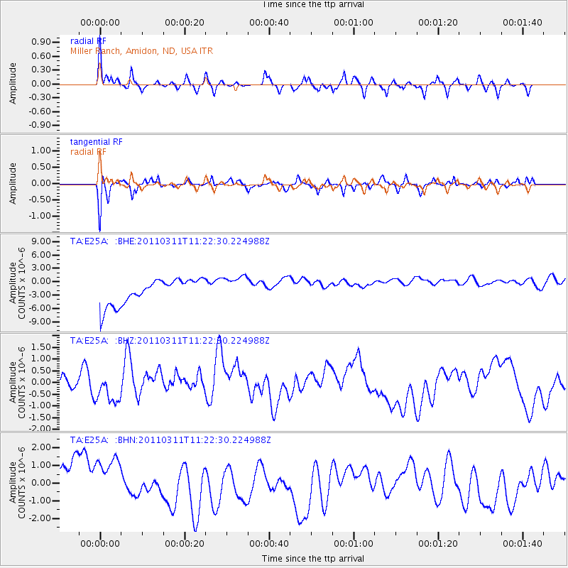
E25A Miller Ranch, Amidon, ND, USA - Earthquake Result Viewer
*The percent match for this event was below the threshold and hence no stack was calculated.
| Earthquake location: |
Near East Coast Of Honshu, Japan |
| Earthquake latitude/longitude: |
35.5/141.8 |
| Earthquake time(UTC): |
2011/03/11 (070) 11:10:58 GMT |
| Earthquake Depth: |
35 km |
| Earthquake Magnitude: |
5.5 MB |
| Earthquake Catalog/Contributor: |
WHDF/NEIC |
|
| Network: |
TA USArray Transportable Network (new EarthScope stations) |
| Station: |
E25A Miller Ranch, Amidon, ND, USA |
| Lat/Lon: |
46.50 N/103.40 W |
| Elevation: |
885 m |
|
| Distance: |
79.5 deg |
| Az: |
39.642 deg |
| Baz: |
311.124 deg |
| Ray Param: |
$rayparam |
*The percent match for this event was below the threshold and hence was not used in the summary stack. |
|
| Radial Match: |
57.021736 % |
| Radial Bump: |
334 |
| Transverse Match: |
64.56787 % |
| Transverse Bump: |
299 |
| SOD ConfigId: |
356183 |
| Insert Time: |
2011-08-14 18:26:32.967 +0000 |
| GWidth: |
2.5 |
| Max Bumps: |
400 |
| Tol: |
0.001 |
|
Signal To Noise
| Channel | StoN | STA | LTA |
| TA:E25A: :BHZ:20110311T11:22:30.224988Z | 0.33538705 | 4.642408E-7 | 1.3841942E-6 |
| TA:E25A: :BHN:20110311T11:22:30.224988Z | 1.1538795 | 1.3417458E-6 | 1.1628127E-6 |
| TA:E25A: :BHE:20110311T11:22:30.224988Z | 1.0226374 | 2.8905422E-6 | 2.8265565E-6 |
| Arrivals |
| Ps | |
| PpPs | |
| PsPs/PpSs | |


