You are here: Home > Network List > TA - USArray Transportable Network (new EarthScope stations) Stations List
> Station L30A Spencer Herefords Ranch, Brewster, NE, USA > Earthquake Result Viewer
L30A Spencer Herefords Ranch, Brewster, NE, USA - Earthquake Result Viewer
| Earthquake location: |
Near East Coast Of Honshu, Japan |
| Earthquake latitude/longitude: |
35.5/141.8 |
| Earthquake time(UTC): |
2011/03/11 (070) 11:10:58 GMT |
| Earthquake Depth: |
35 km |
| Earthquake Magnitude: |
5.5 MB |
| Earthquake Catalog/Contributor: |
WHDF/NEIC |
|
| Network: |
TA USArray Transportable Network (new EarthScope stations) |
| Station: |
L30A Spencer Herefords Ranch, Brewster, NE, USA |
| Lat/Lon: |
41.95 N/99.72 W |
| Elevation: |
782 m |
|
| Distance: |
84.5 deg |
| Az: |
41.221 deg |
| Baz: |
313.906 deg |
| Ray Param: |
0.045381144 |
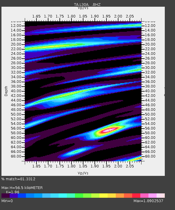
| Estimated Moho Depth: |
56.5 km |
| Estimated Crust Vp/Vs: |
1.96 |
| Assumed Crust Vp: |
6.53 km/s |
| Estimated Crust Vs: |
3.332 km/s |
| Estimated Crust Poisson's Ratio: |
0.32 |
|
| Radial Match: |
81.3312 % |
| Radial Bump: |
364 |
| Transverse Match: |
68.25563 % |
| Transverse Bump: |
400 |
| SOD ConfigId: |
356183 |
| Insert Time: |
2011-08-14 18:33:40.995 +0000 |
| GWidth: |
2.5 |
| Max Bumps: |
400 |
| Tol: |
0.001 |
|

Signal To Noise
| Channel | StoN | STA | LTA |
| TA:L30A: :BHZ:20110311T11:22:56.474988Z | 1.5215414 | 2.3575215E-6 | 1.5494298E-6 |
| TA:L30A: :BHN:20110311T11:22:56.474988Z | 1.1869884 | 1.9042106E-6 | 1.604237E-6 |
| TA:L30A: :BHE:20110311T11:22:56.474988Z | 1.0854671 | 3.0974454E-6 | 2.8535599E-6 |
| Arrivals |
| Ps | 8.5 SECOND |
| PpPs | 25 SECOND |
| PsPs/PpSs | 34 SECOND |


