You are here: Home > Network List > TA - USArray Transportable Network (new EarthScope stations) Stations List
> Station G29A Hoven, SD, USA > Earthquake Result Viewer
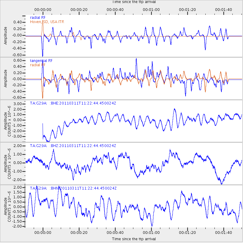
G29A Hoven, SD, USA - Earthquake Result Viewer
*The percent match for this event was below the threshold and hence no stack was calculated.
| Earthquake location: |
Near East Coast Of Honshu, Japan |
| Earthquake latitude/longitude: |
35.5/141.8 |
| Earthquake time(UTC): |
2011/03/11 (070) 11:10:58 GMT |
| Earthquake Depth: |
35 km |
| Earthquake Magnitude: |
5.5 MB |
| Earthquake Catalog/Contributor: |
WHDF/NEIC |
|
| Network: |
TA USArray Transportable Network (new EarthScope stations) |
| Station: |
G29A Hoven, SD, USA |
| Lat/Lon: |
45.19 N/99.92 W |
| Elevation: |
588 m |
|
| Distance: |
82.2 deg |
| Az: |
38.965 deg |
| Baz: |
313.504 deg |
| Ray Param: |
$rayparam |
*The percent match for this event was below the threshold and hence was not used in the summary stack. |
|
| Radial Match: |
42.449245 % |
| Radial Bump: |
400 |
| Transverse Match: |
61.2678 % |
| Transverse Bump: |
369 |
| SOD ConfigId: |
356183 |
| Insert Time: |
2011-08-14 18:34:48.412 +0000 |
| GWidth: |
2.5 |
| Max Bumps: |
400 |
| Tol: |
0.001 |
|
Signal To Noise
| Channel | StoN | STA | LTA |
| TA:G29A: :BHZ:20110311T11:22:44.450024Z | 1.1210704 | 3.6420295E-7 | 3.248707E-7 |
| TA:G29A: :BHN:20110311T11:22:44.450024Z | 1.0303484 | 1.6214261E-6 | 1.5736678E-6 |
| TA:G29A: :BHE:20110311T11:22:44.450024Z | 1.3043969 | 1.7946993E-6 | 1.3758844E-6 |
| Arrivals |
| Ps | |
| PpPs | |
| PsPs/PpSs | |


