You are here: Home > Network List > TA - USArray Transportable Network (new EarthScope stations) Stations List
> Station 333A Richland Springs, TX, USA > Earthquake Result Viewer
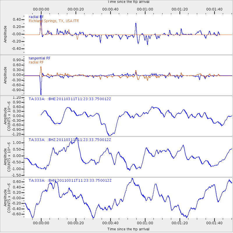
333A Richland Springs, TX, USA - Earthquake Result Viewer
*The percent match for this event was below the threshold and hence no stack was calculated.
| Earthquake location: |
Near East Coast Of Honshu, Japan |
| Earthquake latitude/longitude: |
35.5/141.8 |
| Earthquake time(UTC): |
2011/03/11 (070) 11:10:58 GMT |
| Earthquake Depth: |
35 km |
| Earthquake Magnitude: |
5.5 MB |
| Earthquake Catalog/Contributor: |
WHDF/NEIC |
|
| Network: |
TA USArray Transportable Network (new EarthScope stations) |
| Station: |
333A Richland Springs, TX, USA |
| Lat/Lon: |
31.32 N/98.98 W |
| Elevation: |
443 m |
|
| Distance: |
92.3 deg |
| Az: |
48.404 deg |
| Baz: |
314.542 deg |
| Ray Param: |
$rayparam |
*The percent match for this event was below the threshold and hence was not used in the summary stack. |
|
| Radial Match: |
41.29523 % |
| Radial Bump: |
344 |
| Transverse Match: |
55.970264 % |
| Transverse Bump: |
265 |
| SOD ConfigId: |
356183 |
| Insert Time: |
2011-08-14 18:42:00.990 +0000 |
| GWidth: |
2.5 |
| Max Bumps: |
400 |
| Tol: |
0.001 |
|
Signal To Noise
| Channel | StoN | STA | LTA |
| TA:333A: :BHZ:20110311T11:23:33.750012Z | 1.7274749 | 1.1868613E-6 | 6.8704975E-7 |
| TA:333A: :BHN:20110311T11:23:33.750012Z | 0.19470072 | 1.8754841E-7 | 9.63265E-7 |
| TA:333A: :BHE:20110311T11:23:33.750012Z | 0.58441794 | 1.9094783E-7 | 3.2673165E-7 |
| Arrivals |
| Ps | |
| PpPs | |
| PsPs/PpSs | |


