You are here: Home > Network List > TA - USArray Transportable Network (new EarthScope stations) Stations List
> Station 336A Riesel, TX, USA > Earthquake Result Viewer
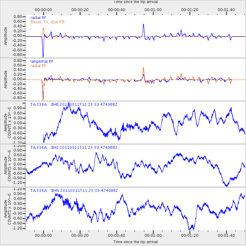
336A Riesel, TX, USA - Earthquake Result Viewer
*The percent match for this event was below the threshold and hence no stack was calculated.
| Earthquake location: |
Near East Coast Of Honshu, Japan |
| Earthquake latitude/longitude: |
35.5/141.8 |
| Earthquake time(UTC): |
2011/03/11 (070) 11:10:58 GMT |
| Earthquake Depth: |
35 km |
| Earthquake Magnitude: |
5.5 MB |
| Earthquake Catalog/Contributor: |
WHDF/NEIC |
|
| Network: |
TA USArray Transportable Network (new EarthScope stations) |
| Station: |
336A Riesel, TX, USA |
| Lat/Lon: |
31.39 N/96.84 W |
| Elevation: |
140 m |
|
| Distance: |
93.6 deg |
| Az: |
47.061 deg |
| Baz: |
315.72 deg |
| Ray Param: |
$rayparam |
*The percent match for this event was below the threshold and hence was not used in the summary stack. |
|
| Radial Match: |
69.71811 % |
| Radial Bump: |
265 |
| Transverse Match: |
62.311234 % |
| Transverse Bump: |
239 |
| SOD ConfigId: |
356183 |
| Insert Time: |
2011-08-14 18:47:53.470 +0000 |
| GWidth: |
2.5 |
| Max Bumps: |
400 |
| Tol: |
0.001 |
|
Signal To Noise
| Channel | StoN | STA | LTA |
| TA:336A: :BHZ:20110311T11:23:39.474988Z | 0.52045155 | 3.8220557E-7 | 7.3437303E-7 |
| TA:336A: :BHN:20110311T11:23:39.474988Z | 0.27879483 | 5.1800106E-7 | 1.858001E-6 |
| TA:336A: :BHE:20110311T11:23:39.474988Z | 1.0519837 | 6.980043E-7 | 6.635125E-7 |
| Arrivals |
| Ps | |
| PpPs | |
| PsPs/PpSs | |


