You are here: Home > Network List > XG92 - Rocky Mountain Front Stations List
> Station SOP Mt Sopris, CO > Earthquake Result Viewer
SOP Mt Sopris, CO - Earthquake Result Viewer
| Earthquake location: |
Southeast Of Honshu, Japan |
| Earthquake latitude/longitude: |
32.5/141.7 |
| Earthquake time(UTC): |
1992/08/11 (224) 15:14:56 GMT |
| Earthquake Depth: |
28 km |
| Earthquake Magnitude: |
5.8 MB, 6.2 MS |
| Earthquake Catalog/Contributor: |
WHDF/NEIC |
|
| Network: |
XG Rocky Mountain Front |
| Station: |
SOP Mt Sopris, CO |
| Lat/Lon: |
39.33 N/107.19 W |
| Elevation: |
2109 m |
|
| Distance: |
84.2 deg |
| Az: |
46.661 deg |
| Baz: |
307.62 deg |
| Ray Param: |
0.04565166 |
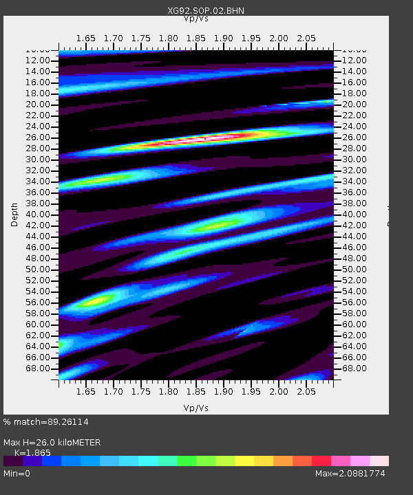
| Estimated Moho Depth: |
26.0 km |
| Estimated Crust Vp/Vs: |
1.87 |
| Assumed Crust Vp: |
6.306 km/s |
| Estimated Crust Vs: |
3.381 km/s |
| Estimated Crust Poisson's Ratio: |
0.30 |
|
| Radial Match: |
89.26114 % |
| Radial Bump: |
400 |
| Transverse Match: |
83.670715 % |
| Transverse Bump: |
400 |
| SOD ConfigId: |
3286 |
| Insert Time: |
2010-02-25 20:11:25.879 +0000 |
| GWidth: |
2.5 |
| Max Bumps: |
400 |
| Tol: |
0.001 |
|

Signal To Noise
| Channel | StoN | STA | LTA |
| XG:SOP:02:BHN:19920811T15:26:54.05802Z | 1.0156256 | 9.1488735E-5 | 9.0081165E-5 |
| XG:SOP:02:BHE:19920811T15:26:54.05802Z | 1.576071 | 1.3032235E-4 | 8.268812E-5 |
| XG:SOP:02:BHZ:19920811T15:26:54.05802Z | 1.2409217 | 6.981455E-5 | 5.6260236E-5 |
| Arrivals |
| Ps | 3.6 SECOND |
| PpPs | 12 SECOND |
| PsPs/PpSs | 15 SECOND |


