You are here: Home > Network List > TA - USArray Transportable Network (new EarthScope stations) Stations List
> Station G32A Webster, SD, USA > Earthquake Result Viewer
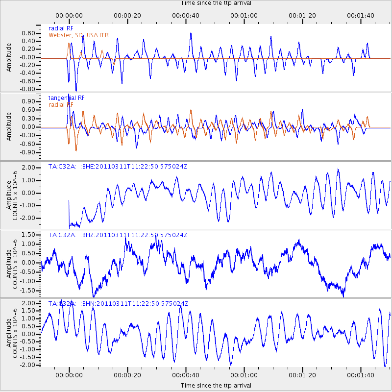
G32A Webster, SD, USA - Earthquake Result Viewer
*The percent match for this event was below the threshold and hence no stack was calculated.
| Earthquake location: |
Near East Coast Of Honshu, Japan |
| Earthquake latitude/longitude: |
35.5/141.8 |
| Earthquake time(UTC): |
2011/03/11 (070) 11:10:58 GMT |
| Earthquake Depth: |
35 km |
| Earthquake Magnitude: |
5.5 MB |
| Earthquake Catalog/Contributor: |
WHDF/NEIC |
|
| Network: |
TA USArray Transportable Network (new EarthScope stations) |
| Station: |
G32A Webster, SD, USA |
| Lat/Lon: |
45.26 N/97.50 W |
| Elevation: |
566 m |
|
| Distance: |
83.3 deg |
| Az: |
37.714 deg |
| Baz: |
315.061 deg |
| Ray Param: |
$rayparam |
*The percent match for this event was below the threshold and hence was not used in the summary stack. |
|
| Radial Match: |
50.620014 % |
| Radial Bump: |
400 |
| Transverse Match: |
63.015255 % |
| Transverse Bump: |
400 |
| SOD ConfigId: |
356183 |
| Insert Time: |
2011-08-14 19:11:57.254 +0000 |
| GWidth: |
2.5 |
| Max Bumps: |
400 |
| Tol: |
0.001 |
|
Signal To Noise
| Channel | StoN | STA | LTA |
| TA:G32A: :BHZ:20110311T11:22:50.575024Z | 3.0749166 | 1.2114843E-6 | 3.9398935E-7 |
| TA:G32A: :BHN:20110311T11:22:50.575024Z | 1.2414861 | 2.0542373E-6 | 1.65466E-6 |
| TA:G32A: :BHE:20110311T11:22:50.575024Z | 1.3850405 | 1.5260706E-6 | 1.1018238E-6 |
| Arrivals |
| Ps | |
| PpPs | |
| PsPs/PpSs | |


