You are here: Home > Network List > TA - USArray Transportable Network (new EarthScope stations) Stations List
> Station V40A Witts Springs, AR, USA > Earthquake Result Viewer
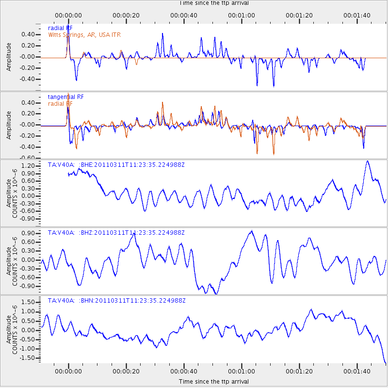
V40A Witts Springs, AR, USA - Earthquake Result Viewer
*The percent match for this event was below the threshold and hence no stack was calculated.
| Earthquake location: |
Near East Coast Of Honshu, Japan |
| Earthquake latitude/longitude: |
35.5/141.8 |
| Earthquake time(UTC): |
2011/03/11 (070) 11:10:58 GMT |
| Earthquake Depth: |
35 km |
| Earthquake Magnitude: |
5.5 MB |
| Earthquake Catalog/Contributor: |
WHDF/NEIC |
|
| Network: |
TA USArray Transportable Network (new EarthScope stations) |
| Station: |
V40A Witts Springs, AR, USA |
| Lat/Lon: |
35.80 N/92.82 W |
| Elevation: |
570 m |
|
| Distance: |
92.7 deg |
| Az: |
41.594 deg |
| Baz: |
318.235 deg |
| Ray Param: |
$rayparam |
*The percent match for this event was below the threshold and hence was not used in the summary stack. |
|
| Radial Match: |
66.12217 % |
| Radial Bump: |
277 |
| Transverse Match: |
52.19933 % |
| Transverse Bump: |
346 |
| SOD ConfigId: |
356183 |
| Insert Time: |
2011-08-14 19:29:42.066 +0000 |
| GWidth: |
2.5 |
| Max Bumps: |
400 |
| Tol: |
0.001 |
|
Signal To Noise
| Channel | StoN | STA | LTA |
| TA:V40A: :BHZ:20110311T11:23:35.224988Z | 1.7467148 | 7.7383305E-7 | 4.4302195E-7 |
| TA:V40A: :BHN:20110311T11:23:35.224988Z | 1.0491377 | 4.2733166E-7 | 4.07317E-7 |
| TA:V40A: :BHE:20110311T11:23:35.224988Z | 1.2684306 | 5.3279507E-7 | 4.2004274E-7 |
| Arrivals |
| Ps | |
| PpPs | |
| PsPs/PpSs | |


