You are here: Home > Network List > XG92 - Rocky Mountain Front Stations List
> Station SOP Mt Sopris, CO > Earthquake Result Viewer
SOP Mt Sopris, CO - Earthquake Result Viewer
| Earthquake location: |
Near Coast Of Peru |
| Earthquake latitude/longitude: |
-10.4/-78.6 |
| Earthquake time(UTC): |
1992/07/17 (199) 18:46:00 GMT |
| Earthquake Depth: |
44 km |
| Earthquake Magnitude: |
5.5 MB, 5.4 MS |
| Earthquake Catalog/Contributor: |
WHDF/NEIC |
|
| Network: |
XG Rocky Mountain Front |
| Station: |
SOP Mt Sopris, CO |
| Lat/Lon: |
39.33 N/107.19 W |
| Elevation: |
2109 m |
|
| Distance: |
56.2 deg |
| Az: |
333.426 deg |
| Baz: |
145.429 deg |
| Ray Param: |
0.06420654 |
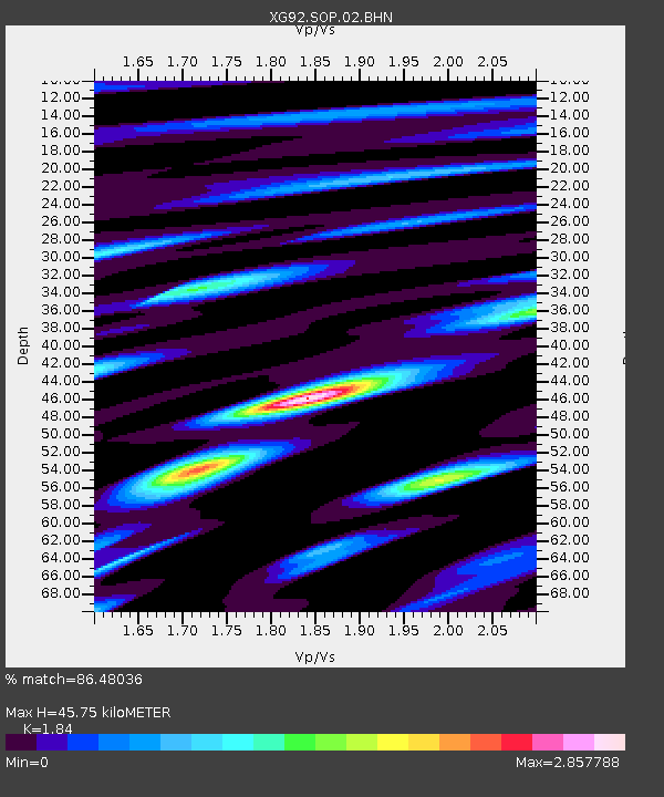
| Estimated Moho Depth: |
45.75 km |
| Estimated Crust Vp/Vs: |
1.84 |
| Assumed Crust Vp: |
6.306 km/s |
| Estimated Crust Vs: |
3.427 km/s |
| Estimated Crust Poisson's Ratio: |
0.29 |
|
| Radial Match: |
86.48036 % |
| Radial Bump: |
400 |
| Transverse Match: |
77.68895 % |
| Transverse Bump: |
400 |
| SOD ConfigId: |
3286 |
| Insert Time: |
2010-02-25 20:11:28.357 +0000 |
| GWidth: |
2.5 |
| Max Bumps: |
400 |
| Tol: |
0.001 |
|

Signal To Noise
| Channel | StoN | STA | LTA |
| XG:SOP:02:BHN:19920717T18:55:04.828003Z | 0.5438253 | 6.79446E-5 | 1.2493829E-4 |
| XG:SOP:02:BHE:19920717T18:55:04.828003Z | 0.49348193 | 5.0276947E-5 | 1.0188204E-4 |
| XG:SOP:02:BHZ:19920717T18:55:04.828003Z | 2.1013877 | 1.6620755E-4 | 7.9094185E-5 |
| Arrivals |
| Ps | 6.4 SECOND |
| PpPs | 20 SECOND |
| PsPs/PpSs | 26 SECOND |


