You are here: Home > Network List > US - United States National Seismic Network Stations List
> Station MNTX Cornudas Mountains, Texas, USA > Earthquake Result Viewer
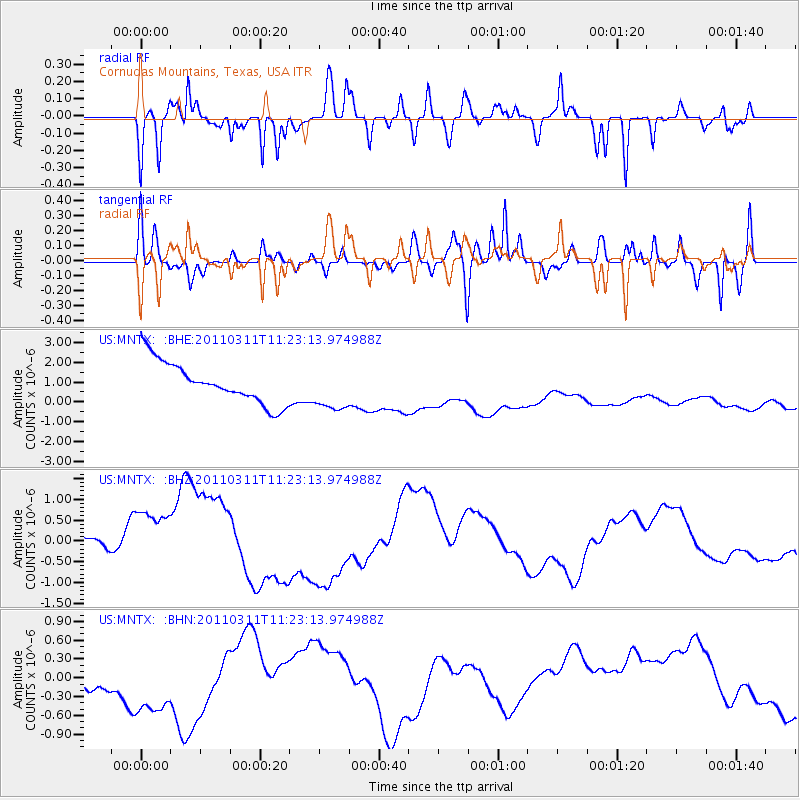
MNTX Cornudas Mountains, Texas, USA - Earthquake Result Viewer
*The percent match for this event was below the threshold and hence no stack was calculated.
| Earthquake location: |
Near East Coast Of Honshu, Japan |
| Earthquake latitude/longitude: |
35.5/141.8 |
| Earthquake time(UTC): |
2011/03/11 (070) 11:10:58 GMT |
| Earthquake Depth: |
35 km |
| Earthquake Magnitude: |
5.5 MB |
| Earthquake Catalog/Contributor: |
WHDF/NEIC |
|
| Network: |
US United States National Seismic Network |
| Station: |
MNTX Cornudas Mountains, Texas, USA |
| Lat/Lon: |
31.70 N/105.38 W |
| Elevation: |
404 m |
|
| Distance: |
88.1 deg |
| Az: |
51.848 deg |
| Baz: |
311.199 deg |
| Ray Param: |
$rayparam |
*The percent match for this event was below the threshold and hence was not used in the summary stack. |
|
| Radial Match: |
68.523865 % |
| Radial Bump: |
395 |
| Transverse Match: |
48.60808 % |
| Transverse Bump: |
400 |
| SOD ConfigId: |
356183 |
| Insert Time: |
2011-08-14 19:38:51.195 +0000 |
| GWidth: |
2.5 |
| Max Bumps: |
400 |
| Tol: |
0.001 |
|
Signal To Noise
| Channel | StoN | STA | LTA |
| US:MNTX: :BHZ:20110311T11:23:13.974988Z | 1.9173499 | 1.0625492E-6 | 5.541759E-7 |
| US:MNTX: :BHN:20110311T11:23:13.974988Z | 1.5340555 | 7.3765176E-7 | 4.8085076E-7 |
| US:MNTX: :BHE:20110311T11:23:13.974988Z | 1.1185154 | 1.1633714E-6 | 1.0401031E-6 |
| Arrivals |
| Ps | |
| PpPs | |
| PsPs/PpSs | |


