You are here: Home > Network List > UW - Pacific Northwest Regional Seismic Network Stations List
> Station LEBA Lebam, WA, USA > Earthquake Result Viewer
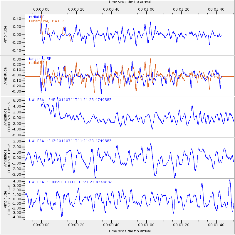
LEBA Lebam, WA, USA - Earthquake Result Viewer
*The percent match for this event was below the threshold and hence no stack was calculated.
| Earthquake location: |
Near East Coast Of Honshu, Japan |
| Earthquake latitude/longitude: |
35.5/141.8 |
| Earthquake time(UTC): |
2011/03/11 (070) 11:10:58 GMT |
| Earthquake Depth: |
35 km |
| Earthquake Magnitude: |
5.5 MB |
| Earthquake Catalog/Contributor: |
WHDF/NEIC |
|
| Network: |
UW Pacific Northwest Regional Seismic Network |
| Station: |
LEBA Lebam, WA, USA |
| Lat/Lon: |
46.55 N/123.56 W |
| Elevation: |
73 m |
|
| Distance: |
68.1 deg |
| Az: |
47.876 deg |
| Baz: |
298.784 deg |
| Ray Param: |
$rayparam |
*The percent match for this event was below the threshold and hence was not used in the summary stack. |
|
| Radial Match: |
55.28653 % |
| Radial Bump: |
400 |
| Transverse Match: |
50.62176 % |
| Transverse Bump: |
400 |
| SOD ConfigId: |
356183 |
| Insert Time: |
2011-08-14 19:48:07.187 +0000 |
| GWidth: |
2.5 |
| Max Bumps: |
400 |
| Tol: |
0.001 |
|
Signal To Noise
| Channel | StoN | STA | LTA |
| UW:LEBA: :BHZ:20110311T11:21:23.474988Z | 0.98236704 | 1.3476323E-6 | 1.3718216E-6 |
| UW:LEBA: :BHN:20110311T11:21:23.474988Z | 1.4599314 | 1.4273229E-6 | 9.776644E-7 |
| UW:LEBA: :BHE:20110311T11:21:23.474988Z | 1.0704404 | 2.1967167E-6 | 2.0521616E-6 |
| Arrivals |
| Ps | |
| PpPs | |
| PsPs/PpSs | |


