You are here: Home > Network List > TA - USArray Transportable Network (new EarthScope stations) Stations List
> Station M04C Macdoel, CA, USA > Earthquake Result Viewer
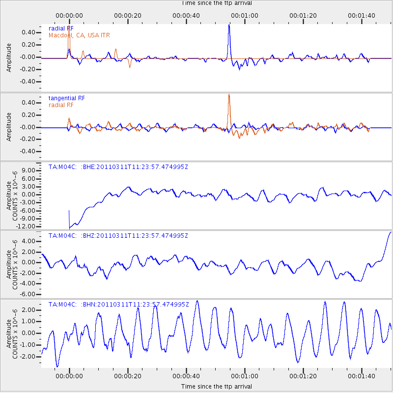
M04C Macdoel, CA, USA - Earthquake Result Viewer
*The percent match for this event was below the threshold and hence no stack was calculated.
| Earthquake location: |
Near East Coast Of Honshu, Japan |
| Earthquake latitude/longitude: |
36.4/141.8 |
| Earthquake time(UTC): |
2011/03/11 (070) 11:13:12 GMT |
| Earthquake Depth: |
26 km |
| Earthquake Magnitude: |
5.5 MB |
| Earthquake Catalog/Contributor: |
WHDF/NEIC |
|
| Network: |
TA USArray Transportable Network (new EarthScope stations) |
| Station: |
M04C Macdoel, CA, USA |
| Lat/Lon: |
41.78 N/121.84 W |
| Elevation: |
1391 m |
|
| Distance: |
71.0 deg |
| Az: |
51.804 deg |
| Baz: |
302.004 deg |
| Ray Param: |
$rayparam |
*The percent match for this event was below the threshold and hence was not used in the summary stack. |
|
| Radial Match: |
86.64193 % |
| Radial Bump: |
400 |
| Transverse Match: |
50.144047 % |
| Transverse Bump: |
400 |
| SOD ConfigId: |
356183 |
| Insert Time: |
2011-08-14 20:56:54.802 +0000 |
| GWidth: |
2.5 |
| Max Bumps: |
400 |
| Tol: |
0.001 |
|
Signal To Noise
| Channel | StoN | STA | LTA |
| TA:M04C: :BHZ:20110311T11:23:57.474995Z | 1.5346483 | 2.3124967E-6 | 1.5068578E-6 |
| TA:M04C: :BHN:20110311T11:23:57.474995Z | 0.3681181 | 5.6703146E-7 | 1.5403521E-6 |
| TA:M04C: :BHE:20110311T11:23:57.474995Z | 0.95748526 | 4.290428E-6 | 4.480934E-6 |
| Arrivals |
| Ps | |
| PpPs | |
| PsPs/PpSs | |


