You are here: Home > Network List > TA - USArray Transportable Network (new EarthScope stations) Stations List
> Station H29A Onida, SD, USA > Earthquake Result Viewer
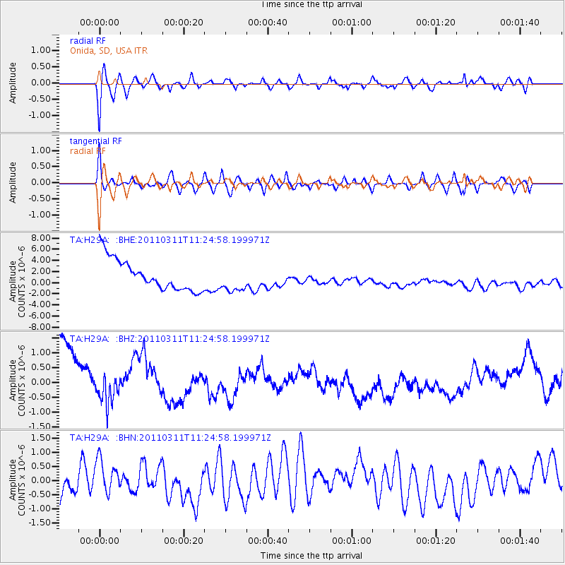
H29A Onida, SD, USA - Earthquake Result Viewer
*The percent match for this event was below the threshold and hence no stack was calculated.
| Earthquake location: |
Near East Coast Of Honshu, Japan |
| Earthquake latitude/longitude: |
36.4/141.8 |
| Earthquake time(UTC): |
2011/03/11 (070) 11:13:12 GMT |
| Earthquake Depth: |
26 km |
| Earthquake Magnitude: |
5.5 MB |
| Earthquake Catalog/Contributor: |
WHDF/NEIC |
|
| Network: |
TA USArray Transportable Network (new EarthScope stations) |
| Station: |
H29A Onida, SD, USA |
| Lat/Lon: |
44.63 N/100.21 W |
| Elevation: |
548 m |
|
| Distance: |
81.8 deg |
| Az: |
39.565 deg |
| Baz: |
313.958 deg |
| Ray Param: |
$rayparam |
*The percent match for this event was below the threshold and hence was not used in the summary stack. |
|
| Radial Match: |
53.28577 % |
| Radial Bump: |
400 |
| Transverse Match: |
45.17883 % |
| Transverse Bump: |
400 |
| SOD ConfigId: |
356183 |
| Insert Time: |
2011-08-14 21:12:31.211 +0000 |
| GWidth: |
2.5 |
| Max Bumps: |
400 |
| Tol: |
0.001 |
|
Signal To Noise
| Channel | StoN | STA | LTA |
| TA:H29A: :BHZ:20110311T11:24:58.199971Z | 0.32455838 | 4.2747178E-7 | 1.3170876E-6 |
| TA:H29A: :BHN:20110311T11:24:58.199971Z | 1.4578705 | 6.402402E-7 | 4.3916125E-7 |
| TA:H29A: :BHE:20110311T11:24:58.199971Z | 0.8717174 | 2.392412E-6 | 2.7444812E-6 |
| Arrivals |
| Ps | |
| PpPs | |
| PsPs/PpSs | |


