You are here: Home > Network List > TA - USArray Transportable Network (new EarthScope stations) Stations List
> Station X33A Lawton, OK, USA > Earthquake Result Viewer
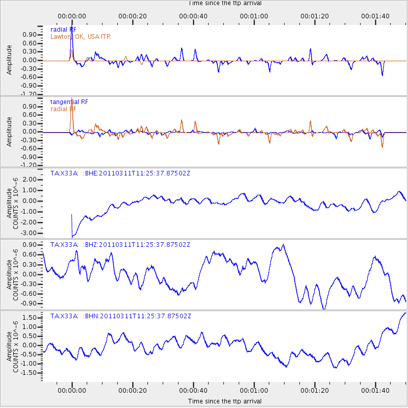
X33A Lawton, OK, USA - Earthquake Result Viewer
*The percent match for this event was below the threshold and hence no stack was calculated.
| Earthquake location: |
Near East Coast Of Honshu, Japan |
| Earthquake latitude/longitude: |
36.4/141.8 |
| Earthquake time(UTC): |
2011/03/11 (070) 11:13:12 GMT |
| Earthquake Depth: |
26 km |
| Earthquake Magnitude: |
5.5 MB |
| Earthquake Catalog/Contributor: |
WHDF/NEIC |
|
| Network: |
TA USArray Transportable Network (new EarthScope stations) |
| Station: |
X33A Lawton, OK, USA |
| Lat/Lon: |
34.54 N/98.50 W |
| Elevation: |
346 m |
|
| Distance: |
89.8 deg |
| Az: |
45.799 deg |
| Baz: |
315.506 deg |
| Ray Param: |
$rayparam |
*The percent match for this event was below the threshold and hence was not used in the summary stack. |
|
| Radial Match: |
35.30632 % |
| Radial Bump: |
205 |
| Transverse Match: |
49.213882 % |
| Transverse Bump: |
348 |
| SOD ConfigId: |
356183 |
| Insert Time: |
2011-08-14 21:16:27.758 +0000 |
| GWidth: |
2.5 |
| Max Bumps: |
400 |
| Tol: |
0.001 |
|
Signal To Noise
| Channel | StoN | STA | LTA |
| TA:X33A: :BHZ:20110311T11:25:37.87502Z | 1.0403136 | 1.4804724E-6 | 1.423102E-6 |
| TA:X33A: :BHN:20110311T11:25:37.87502Z | 1.1204883 | 9.530788E-7 | 8.505924E-7 |
| TA:X33A: :BHE:20110311T11:25:37.87502Z | 1.1584221 | 1.0823227E-6 | 9.343077E-7 |
| Arrivals |
| Ps | |
| PpPs | |
| PsPs/PpSs | |


