You are here: Home > Network List > TA - USArray Transportable Network (new EarthScope stations) Stations List
> Station 535A Dale, TX, USA > Earthquake Result Viewer
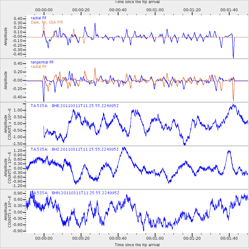
535A Dale, TX, USA - Earthquake Result Viewer
*The percent match for this event was below the threshold and hence no stack was calculated.
| Earthquake location: |
Near East Coast Of Honshu, Japan |
| Earthquake latitude/longitude: |
36.4/141.8 |
| Earthquake time(UTC): |
2011/03/11 (070) 11:13:12 GMT |
| Earthquake Depth: |
26 km |
| Earthquake Magnitude: |
5.5 MB |
| Earthquake Catalog/Contributor: |
WHDF/NEIC |
|
| Network: |
TA USArray Transportable Network (new EarthScope stations) |
| Station: |
535A Dale, TX, USA |
| Lat/Lon: |
30.03 N/97.57 W |
| Elevation: |
170 m |
|
| Distance: |
93.6 deg |
| Az: |
48.377 deg |
| Baz: |
315.923 deg |
| Ray Param: |
$rayparam |
*The percent match for this event was below the threshold and hence was not used in the summary stack. |
|
| Radial Match: |
23.101896 % |
| Radial Bump: |
400 |
| Transverse Match: |
75.90076 % |
| Transverse Bump: |
400 |
| SOD ConfigId: |
356183 |
| Insert Time: |
2011-08-14 21:25:54.042 +0000 |
| GWidth: |
2.5 |
| Max Bumps: |
400 |
| Tol: |
0.001 |
|
Signal To Noise
| Channel | StoN | STA | LTA |
| TA:535A: :BHZ:20110311T11:25:55.224995Z | 1.0755626 | 1.3285376E-6 | 1.2352025E-6 |
| TA:535A: :BHN:20110311T11:25:55.224995Z | 0.850612 | 5.178081E-7 | 6.0874765E-7 |
| TA:535A: :BHE:20110311T11:25:55.224995Z | 0.7476673 | 4.876127E-7 | 6.5217864E-7 |
| Arrivals |
| Ps | |
| PpPs | |
| PsPs/PpSs | |


