You are here: Home > Network List > TA - USArray Transportable Network (new EarthScope stations) Stations List
> Station U37A Salina, OK, USA > Earthquake Result Viewer
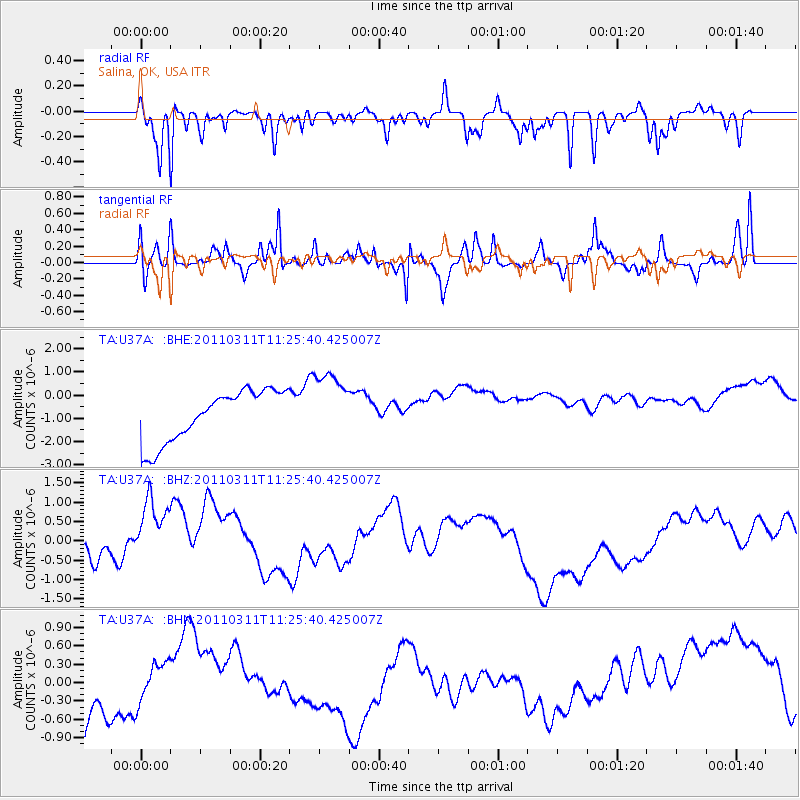
U37A Salina, OK, USA - Earthquake Result Viewer
*The percent match for this event was below the threshold and hence no stack was calculated.
| Earthquake location: |
Near East Coast Of Honshu, Japan |
| Earthquake latitude/longitude: |
36.4/141.8 |
| Earthquake time(UTC): |
2011/03/11 (070) 11:13:12 GMT |
| Earthquake Depth: |
26 km |
| Earthquake Magnitude: |
5.5 MB |
| Earthquake Catalog/Contributor: |
WHDF/NEIC |
|
| Network: |
TA USArray Transportable Network (new EarthScope stations) |
| Station: |
U37A Salina, OK, USA |
| Lat/Lon: |
36.41 N/95.12 W |
| Elevation: |
248 m |
|
| Distance: |
90.4 deg |
| Az: |
42.515 deg |
| Baz: |
317.468 deg |
| Ray Param: |
$rayparam |
*The percent match for this event was below the threshold and hence was not used in the summary stack. |
|
| Radial Match: |
39.348263 % |
| Radial Bump: |
275 |
| Transverse Match: |
59.0989 % |
| Transverse Bump: |
295 |
| SOD ConfigId: |
356183 |
| Insert Time: |
2011-08-14 21:39:19.529 +0000 |
| GWidth: |
2.5 |
| Max Bumps: |
400 |
| Tol: |
0.001 |
|
Signal To Noise
| Channel | StoN | STA | LTA |
| TA:U37A: :BHZ:20110311T11:25:40.425007Z | 4.4534273 | 1.2684914E-6 | 2.8483487E-7 |
| TA:U37A: :BHN:20110311T11:25:40.425007Z | 0.31719562 | 4.0272425E-7 | 1.26964E-6 |
| TA:U37A: :BHE:20110311T11:25:40.425007Z | 1.3536428 | 1.4875831E-6 | 1.098948E-6 |
| Arrivals |
| Ps | |
| PpPs | |
| PsPs/PpSs | |


