You are here: Home > Network List > TA - USArray Transportable Network (new EarthScope stations) Stations List
> Station U35A Pawnee, OK, USA > Earthquake Result Viewer
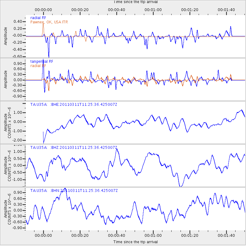
U35A Pawnee, OK, USA - Earthquake Result Viewer
*The percent match for this event was below the threshold and hence no stack was calculated.
| Earthquake location: |
Near East Coast Of Honshu, Japan |
| Earthquake latitude/longitude: |
36.4/141.8 |
| Earthquake time(UTC): |
2011/03/11 (070) 11:13:12 GMT |
| Earthquake Depth: |
26 km |
| Earthquake Magnitude: |
5.5 MB |
| Earthquake Catalog/Contributor: |
WHDF/NEIC |
|
| Network: |
TA USArray Transportable Network (new EarthScope stations) |
| Station: |
U35A Pawnee, OK, USA |
| Lat/Lon: |
36.37 N/96.73 W |
| Elevation: |
303 m |
|
| Distance: |
89.5 deg |
| Az: |
43.492 deg |
| Baz: |
316.514 deg |
| Ray Param: |
$rayparam |
*The percent match for this event was below the threshold and hence was not used in the summary stack. |
|
| Radial Match: |
45.927776 % |
| Radial Bump: |
371 |
| Transverse Match: |
62.628895 % |
| Transverse Bump: |
357 |
| SOD ConfigId: |
356183 |
| Insert Time: |
2011-08-14 21:40:04.378 +0000 |
| GWidth: |
2.5 |
| Max Bumps: |
400 |
| Tol: |
0.001 |
|
Signal To Noise
| Channel | StoN | STA | LTA |
| TA:U35A: :BHZ:20110311T11:25:36.425007Z | 2.544446 | 6.7889164E-7 | 2.6681315E-7 |
| TA:U35A: :BHN:20110311T11:25:36.425007Z | 0.39095572 | 3.5546336E-7 | 9.092164E-7 |
| TA:U35A: :BHE:20110311T11:25:36.425007Z | 1.0428648 | 7.596406E-7 | 7.2841715E-7 |
| Arrivals |
| Ps | |
| PpPs | |
| PsPs/PpSs | |


