You are here: Home > Network List > TA - USArray Transportable Network (new EarthScope stations) Stations List
> Station A04D Lummi Island, WA, USA > Earthquake Result Viewer
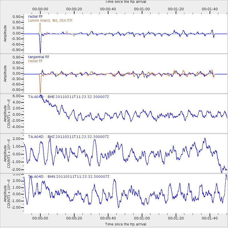
A04D Lummi Island, WA, USA - Earthquake Result Viewer
*The percent match for this event was below the threshold and hence no stack was calculated.
| Earthquake location: |
Near East Coast Of Honshu, Japan |
| Earthquake latitude/longitude: |
36.4/141.8 |
| Earthquake time(UTC): |
2011/03/11 (070) 11:13:12 GMT |
| Earthquake Depth: |
26 km |
| Earthquake Magnitude: |
5.5 MB |
| Earthquake Catalog/Contributor: |
WHDF/NEIC |
|
| Network: |
TA USArray Transportable Network (new EarthScope stations) |
| Station: |
A04D Lummi Island, WA, USA |
| Lat/Lon: |
48.72 N/122.71 W |
| Elevation: |
13 m |
|
| Distance: |
67.0 deg |
| Az: |
45.744 deg |
| Baz: |
299.215 deg |
| Ray Param: |
$rayparam |
*The percent match for this event was below the threshold and hence was not used in the summary stack. |
|
| Radial Match: |
87.64399 % |
| Radial Bump: |
325 |
| Transverse Match: |
49.996037 % |
| Transverse Bump: |
400 |
| SOD ConfigId: |
356183 |
| Insert Time: |
2011-08-14 21:46:15.598 +0000 |
| GWidth: |
2.5 |
| Max Bumps: |
400 |
| Tol: |
0.001 |
|
Signal To Noise
| Channel | StoN | STA | LTA |
| TA:A04D: :BHZ:20110311T11:23:32.300007Z | 0.9406655 | 2.467943E-6 | 2.623614E-6 |
| TA:A04D: :BHN:20110311T11:23:32.300007Z | 0.92211425 | 2.4250955E-6 | 2.6299294E-6 |
| TA:A04D: :BHE:20110311T11:23:32.300007Z | 1.1812117 | 2.5285728E-6 | 2.1406602E-6 |
| Arrivals |
| Ps | |
| PpPs | |
| PsPs/PpSs | |


