You are here: Home > Network List > TA - USArray Transportable Network (new EarthScope stations) Stations List
> Station C06D Leavenworth, WQ, USA > Earthquake Result Viewer
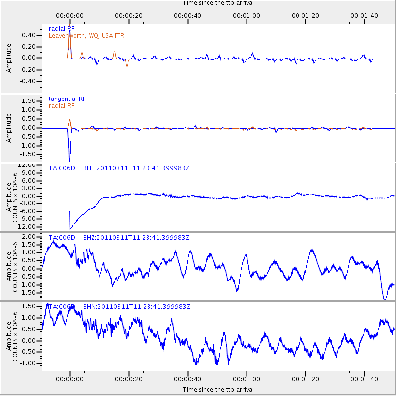
C06D Leavenworth, WQ, USA - Earthquake Result Viewer
*The percent match for this event was below the threshold and hence no stack was calculated.
| Earthquake location: |
Near East Coast Of Honshu, Japan |
| Earthquake latitude/longitude: |
36.4/141.8 |
| Earthquake time(UTC): |
2011/03/11 (070) 11:13:12 GMT |
| Earthquake Depth: |
26 km |
| Earthquake Magnitude: |
5.5 MB |
| Earthquake Catalog/Contributor: |
WHDF/NEIC |
|
| Network: |
TA USArray Transportable Network (new EarthScope stations) |
| Station: |
C06D Leavenworth, WQ, USA |
| Lat/Lon: |
47.92 N/120.89 W |
| Elevation: |
544 m |
|
| Distance: |
68.4 deg |
| Az: |
45.84 deg |
| Baz: |
300.601 deg |
| Ray Param: |
$rayparam |
*The percent match for this event was below the threshold and hence was not used in the summary stack. |
|
| Radial Match: |
59.28099 % |
| Radial Bump: |
203 |
| Transverse Match: |
93.51681 % |
| Transverse Bump: |
120 |
| SOD ConfigId: |
356183 |
| Insert Time: |
2011-08-14 21:51:57.277 +0000 |
| GWidth: |
2.5 |
| Max Bumps: |
400 |
| Tol: |
0.001 |
|
Signal To Noise
| Channel | StoN | STA | LTA |
| TA:C06D: :BHZ:20110311T11:23:41.399983Z | 0.8891717 | 3.41259E-6 | 3.8379426E-6 |
| TA:C06D: :BHN:20110311T11:23:41.399983Z | 1.0274374 | 4.544613E-6 | 4.42325E-6 |
| TA:C06D: :BHE:20110311T11:23:41.399983Z | 0.7740863 | 3.1567292E-6 | 4.078007E-6 |
| Arrivals |
| Ps | |
| PpPs | |
| PsPs/PpSs | |


