You are here: Home > Network List > 2G - Testing of the effectiveness of incorporating seismic data in seismic hazard ass Stations List
> Station IUGFS Indiana Univ Geologic Field Station, Cardwell, MT > Earthquake Result Viewer
IUGFS Indiana Univ Geologic Field Station, Cardwell, MT - Earthquake Result Viewer
| Earthquake location: |
Vanuatu Islands |
| Earthquake latitude/longitude: |
-15.1/167.4 |
| Earthquake time(UTC): |
2014/02/07 (038) 08:40:13 GMT |
| Earthquake Depth: |
122 km |
| Earthquake Magnitude: |
6.5 MWW, 6.5 MWC, 6.5 MWB, 6.5 MI |
| Earthquake Catalog/Contributor: |
NEIC PDE/NEIC COMCAT |
|
| Network: |
2G Testing of the effectiveness of incorporating seismic data in seismic hazard ass |
| Station: |
IUGFS Indiana Univ Geologic Field Station, Cardwell, MT |
| Lat/Lon: |
45.73 N/111.97 W |
| Elevation: |
1634 m |
|
| Distance: |
94.3 deg |
| Az: |
43.876 deg |
| Baz: |
252.919 deg |
| Ray Param: |
0.04100091 |
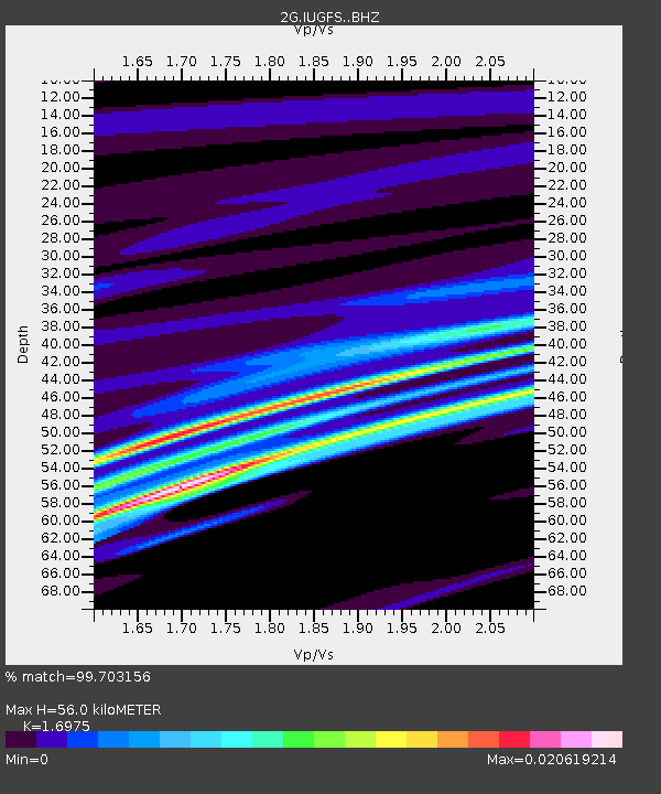
| Estimated Moho Depth: |
56.0 km |
| Estimated Crust Vp/Vs: |
1.70 |
| Assumed Crust Vp: |
6.35 km/s |
| Estimated Crust Vs: |
3.741 km/s |
| Estimated Crust Poisson's Ratio: |
0.23 |
|
| Radial Match: |
99.703156 % |
| Radial Bump: |
53 |
| Transverse Match: |
99.835464 % |
| Transverse Bump: |
18 |
| SOD ConfigId: |
3390531 |
| Insert Time: |
2019-04-10 06:24:34.592 +0000 |
| GWidth: |
2.5 |
| Max Bumps: |
400 |
| Tol: |
0.001 |
|

Signal To Noise
| Channel | StoN | STA | LTA |
| 2G:IUGFS: :BHZ:20140207T08:52:47.250012Z | 2.943644 | 2.1318928E-7 | 7.2423596E-8 |
| 2G:IUGFS: :BHN:20140207T08:52:47.250012Z | 2.9199173 | 2.530406E-7 | 8.66602E-8 |
| 2G:IUGFS: :BHE:20140207T08:52:47.250012Z | 0.7127429 | 3.0641192E-9 | 4.2990522E-9 |
| Arrivals |
| Ps | 6.3 SECOND |
| PpPs | 23 SECOND |
| PsPs/PpSs | 30 SECOND |


